Codogno geodata
Codogno (Lombardy) is a seat of a third-order administrative division; located in Italy in Europe/Rome (GMT+2) time zone. With population of 14,583 people, there are 620 cities with bigger population in this country. Compared to other cities in Italy, 64.1% of cities are located further ↓South; 70.7% of cities are located further →East and 77.5% of cities have higher elevation than Codogno. Note1


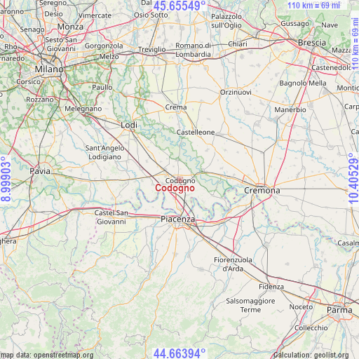
Codogno GPS coordinates[2]
45° 9' 42.732" North, 9° 42' 7.776" East
| Map corner | latitude | longitude |
|---|---|---|
| Upper-left | 45.65549°, | 8.99903° |
| Center: | 45.16187°, | 9.70216° |
| Lower-right: | 44.66394°, | 10.40529° |
| Map W x H: | 110.3×110.3 km | = 68.5×68.5mi |
| max Lat: | 47.04031° ⇑35.9% North |
| Codogno: | 45.16187° |
| min Lat: | ⇓64.1% South 35.50142° |
| min Long | Codogno | max Long |
| 6.69888° | 9.70216° | 18.48682° |
| W 29.3%⇐ | ⇒70.7% E |
Elevation
Elevation of Codogno is 62 m = 203 ft, and this is 244.7 m = 803 ft below average elevation for this country.
| Max E: |
2085 m = 6841 ft | 77.5% |
| Avg. | 306.7 m = 1006 ft | |
| Codogno | 62 m = 203 ft | |
Min E: |
-4 m = -13 ft | 22.5% |
See also: Italy elevation on elevation.city.
Geographical zone
Codogno is located in North temperate zone (between Tropic of Cancer and the Arctic Circle). Distance of this North polar circle is 2379.6 km =1478.6 mi to North.| Distance of | km | miles | from Codogno |
|---|---|---|---|
| North Pole | 4985.5 | 3097.8 | to North |
| Arctic Circle | 2379.6 | 1478.6 | to North |
| Tropic Cancer | 2415.6 | 1501 | to South |
| Equator | 5021.5 | 3120.2 | to South |


Nearby cities:
15 places around Codogno: (largest is in red/bold)
• Camairago
5.2 km =3.2 mi,  22°
22°
• Casalpusterlengo
4.6 km =2.9 mi,  294°
294°
• Castiglione d'Adda
6.2 km =3.9 mi,  353°
353°
• Cavacurta
4.4 km =2.7 mi,  45°
45°
• Corno Giovine
5.3 km =3.3 mi,  125°
125°
• Fombio
2.9 km =1.8 mi,  216°
216°
• Fornaci
4.5 km =2.8 mi,  335°
335°
• Guardamiglio
6.2 km =3.9 mi,  192°
192°
• Maleo
4.7 km =2.9 mi,  84°
84°
• Retegno
1.4 km =0.9 mi, 191°
• San Fiorano
3 km =1.9 mi,  151°
151°
• San Martino Pizzolano
6.4 km =4 mi,  271°
271°
• Santo Stefano Lodigiano
5.5 km =3.4 mi, 151°
• Somaglia
5.6 km =3.5 mi,  255°
255°
• Terranova dei Passerini
6.7 km =4.2 mi,  331°
331°
Sources, notices
• [Note1] Compared only with cities in Italy existing in our database
• [Src1] Map data: © OpenStreetMap contributors (CC-BY-SA)
• [Src2] Other city data from geonames.org with taken over terms of usage.
• [Src3] Geographical zone / Annual Mean Temperature by Robert A. Rohde @ Wikipedia
