Carpenedolo geodata
Carpenedolo (Lombardy) is a seat of a third-order administrative division; located in Italy in Europe/Rome (GMT+2) time zone. With population of 11,589 people, there are 807 cities with bigger population in this country. Compared to other cities in Italy, 69.2% of cities are located further ↓South; 63.6% of cities are located further →East and 74.3% of cities have higher elevation than Carpenedolo. Note1


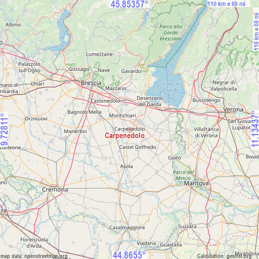
Carpenedolo GPS coordinates[2]
45° 21' 42.084" North, 10° 25' 52.464" East
| Map corner | latitude | longitude |
|---|---|---|
| Upper-left | 45.85357°, | 9.72811° |
| Center: | 45.36169°, | 10.43124° |
| Lower-right: | 44.8655°, | 11.13437° |
| Map W x H: | 109.9×109.9 km | = 68.3×68.3mi |
| max Lat: | 47.04031° ⇑30.8% North |
| Carpenedolo: | 45.36169° |
| min Lat: | ⇓69.2% South 35.50142° |
| min Long | Carpenedolo | max Long |
| 6.69888° | 10.43124° | 18.48682° |
| W 36.4%⇐ | ⇒63.6% E |
Elevation
Elevation of Carpenedolo is 77 m = 253 ft, and this is 229.7 m = 754 ft below average elevation for this country.
| Max E: |
2085 m = 6841 ft | 74.3% |
| Avg. | 306.7 m = 1006 ft | |
| Carpenedolo | 77 m = 253 ft | |
Min E: |
-4 m = -13 ft | 25.7% |
See also: Italy elevation on elevation.city.
Geographical zone
Carpenedolo is located in North temperate zone (between Tropic of Cancer and the Arctic Circle). Distance of this North polar circle is 2357.4 km =1464.8 mi to North.| Distance of | km | miles | from Carpenedolo |
|---|---|---|---|
| North Pole | 4963.3 | 3084.1 | to North |
| Arctic Circle | 2357.4 | 1464.8 | to North |
| Tropic Cancer | 2437.8 | 1514.8 | to South |
| Equator | 5043.7 | 3134 | to South |


Nearby cities:
15 places around Carpenedolo: (largest is in red/bold)
• Acquafredda
6.2 km =3.9 mi,  192°
192°
• Calvisano
7.2 km =4.5 mi,  255°
255°
• Castel Goffredo
8.2 km =5.1 mi,  156°
156°
• Castiglione delle Stiviere
5.3 km =3.3 mi,  53°
53°
• Esenta
7.2 km =4.5 mi,  32°
32°
• Gozzolina
4.3 km =2.7 mi,  94°
94°
• Grole
7.7 km =4.8 mi,  79°
79°
• Medole
7.6 km =4.7 mi,  121°
121°
• Mezzane
3.1 km =1.9 mi,  240°
240°
• Montichiari
6.3 km =3.9 mi,  335°
335°
• Novagli
2.9 km =1.8 mi,  11°
11°
• Sant'Antonio
7.6 km =4.7 mi,  308°
308°
• Viadana
7.5 km =4.7 mi,  278°
278°
• Vighizzolo
10.1 km =6.3 mi,  323°
323°
• Visano
6.9 km =4.3 mi,  223°
223°
Sources, notices
• [Note1] Compared only with cities in Italy existing in our database
• [Src1] Map data: © OpenStreetMap contributors (CC-BY-SA)
• [Src2] Other city data from geonames.org with taken over terms of usage.
• [Src3] Geographical zone / Annual Mean Temperature by Robert A. Rohde @ Wikipedia
