Vighizzolo geodata
Vighizzolo (Lombardy) is a populated place; located in Italy in Europe/Rome (GMT+2) time zone. With population of 2,798 people, there are 3219 cities with bigger population in this country. Compared to other cities in Italy, 71.4% of cities are located further ↓South; 64.4% of cities are located further →East and 67.6% of cities have higher elevation than Vighizzolo. Note1


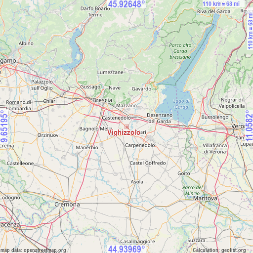
Vighizzolo GPS coordinates[2]
45° 26' 6.864" North, 10° 21' 18.252" East
| Map corner | latitude | longitude |
|---|---|---|
| Upper-left | 45.92648°, | 9.65195° |
| Center: | 45.43524°, | 10.35507° |
| Lower-right: | 44.93969°, | 11.0582° |
| Map W x H: | 109.7×109.7 km | = 68.2×68.2mi |
| max Lat: | 47.04031° ⇑28.6% North |
| Vighizzolo: | 45.43524° |
| min Lat: | ⇓71.4% South 35.50142° |
| min Long | Vighizzolo | max Long |
| 6.69888° | 10.35507° | 18.48682° |
| W 35.6%⇐ | ⇒64.4% E |
Elevation
Elevation of Vighizzolo is 111 m = 364 ft, and this is 195.7 m = 642 ft below average elevation for this country.
| Max E: |
2085 m = 6841 ft | 67.6% |
| Avg. | 306.7 m = 1006 ft | |
| Vighizzolo | 111 m = 364 ft | |
Min E: |
-4 m = -13 ft | 32.4% |
See also: Italy elevation on elevation.city.
Geographical zone
Vighizzolo is located in North temperate zone (between Tropic of Cancer and the Arctic Circle). Distance of this North polar circle is 2349.2 km =1459.7 mi to North.| Distance of | km | miles | from Vighizzolo |
|---|---|---|---|
| North Pole | 4955.1 | 3079 | to North |
| Arctic Circle | 2349.2 | 1459.7 | to North |
| Tropic Cancer | 2446 | 1519.9 | to South |
| Equator | 5051.9 | 3139.1 | to South |


Nearby cities:
15 places around Vighizzolo: (largest is in red/bold)
• Bettole
9 km =5.6 mi,  312°
312°
• Buffalora-Bettole
9.3 km =5.8 mi,  317°
317°
• Calcinato
4.9 km =3 mi,  59°
59°
• Campagnola
6.8 km =4.2 mi,  36°
36°
• Capodimonte
7.8 km =4.8 mi,  296°
296°
• Castenedolo
6.6 km =4.1 mi, 311°
• Ghedi
7.1 km =4.4 mi,  238°
238°
• Molinetto
6.6 km =4.1 mi,  2°
2°
• Montichiari
4.2 km =2.6 mi,  126°
126°
• Novagli
8.5 km =5.3 mi, 129°
• Patuzza
8.8 km =5.5 mi,  12°
12°
• Ponte San Marco
6.5 km =4 mi, 44°
• Rezzato
9 km =5.6 mi,  340°
340°
• Sant'Antonio
3.4 km =2.1 mi,  179°
179°
• Viadana
7.2 km =4.5 mi,  191°
191°
Sources, notices
• [Note1] Compared only with cities in Italy existing in our database
• [Src1] Map data: © OpenStreetMap contributors (CC-BY-SA)
• [Src2] Other city data from geonames.org with taken over terms of usage.
• [Src3] Geographical zone / Annual Mean Temperature by Robert A. Rohde @ Wikipedia
