Carnago geodata
Carnago (Lombardy) is a seat of a third-order administrative division; located in Italy in Europe/Rome (GMT+2) time zone. With population of 5,354 people, there are 1826 cities with bigger population in this country. Compared to other cities in Italy, 82.3% of cities are located further ↓South; 83.7% of cities are located further →East and 66.1% of cities have lower elevation than Carnago. Note1


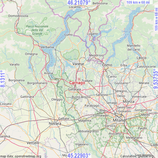
Carnago GPS coordinates[2]
45° 43' 19.452" North, 8° 50' 3.228" East
| Map corner | latitude | longitude |
|---|---|---|
| Upper-left | 46.21079°, | 8.1311° |
| Center: | 45.72207°, | 8.83423° |
| Lower-right: | 45.22903°, | 9.53735° |
| Map W x H: | 109.2×109.2 km | = 67.9×67.9mi |
| max Lat: | 47.04031° ⇑17.7% North |
| Carnago: | 45.72207° |
| min Lat: | ⇓82.3% South 35.50142° |
| min Long | Carnago | max Long |
| 6.69888° | 8.83423° | 18.48682° |
| W 16.3%⇐ | ⇒83.7% E |
Elevation
Elevation of Carnago is 354 m = 1161 ft, and this is 47.3 m = 155 ft above average elevation for this country.
| Max E: |
2085 m = 6841 ft | 33.9% |
| Carnago | 354 m 1161 ft | |
| Avg. | 306.7 m = 1006 ft | |
Min E: |
-4 m = -13 ft | 66.1% |
See also: Italy elevation on elevation.city.
Geographical zone
Carnago is located in North temperate zone (between Tropic of Cancer and the Arctic Circle). Distance of this North polar circle is 2317.4 km =1440 mi to North.| Distance of | km | miles | from Carnago |
|---|---|---|---|
| North Pole | 4923.2 | 3059.1 | to North |
| Arctic Circle | 2317.4 | 1440 | to North |
| Tropic Cancer | 2477.9 | 1539.7 | to South |
| Equator | 5083.8 | 3158.9 | to South |


Nearby cities:
15 places around Carnago: (largest is in red/bold)
• Albizzate
2.5 km =1.6 mi,  282°
282°
• Bolladello-Peveranza
4 km =2.5 mi,  167°
167°
• Caronno Varesino
1.5 km =0.9 mi,  352°
352°
• Castelseprio
2.3 km =1.4 mi,  113°
113°
• Castronno
3.3 km =2.1 mi,  331°
331°
• Cavaria Con Premezzo
4.1 km =2.5 mi,  216°
216°
• Gornate Olona
2.9 km =1.8 mi,  42°
42°
• Gornate Superiore
4.1 km =2.5 mi,  30°
30°
• Jerago Con Orago
3.5 km =2.2 mi,  236°
236°
• Lonate Ceppino
3.8 km =2.4 mi, 113°
• Monte
1.2 km =0.7 mi,  229°
229°
• Oggiona-Santo Stefano
2.4 km =1.5 mi,  214°
214°
• Rovate
1.6 km =1 mi,  145°
145°
• Solbiate Arno
1.6 km =1 mi,  260°
260°
• Sumirago
4.2 km =2.6 mi,  292°
292°
Sources, notices
• [Note1] Compared only with cities in Italy existing in our database
• [Src1] Map data: © OpenStreetMap contributors (CC-BY-SA)
• [Src2] Other city data from geonames.org with taken over terms of usage.
• [Src3] Geographical zone / Annual Mean Temperature by Robert A. Rohde @ Wikipedia
