Carcoforo geodata
Carcoforo (Piedmont) is a seat of a third-order administrative division; located in Italy in Europe/Rome (GMT+2) time zone. With population of 73 people, there are 11527 cities with bigger population in this country. Compared to other cities in Italy, 89.4% of cities are located further ↓South; 93% of cities are located further →East and 99.1% of cities have lower elevation than Carcoforo. Note1


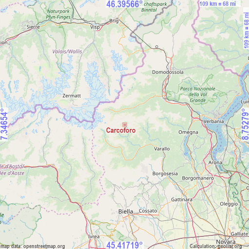
Carcoforo GPS coordinates[2]
45° 54' 30.888" North, 8° 2' 58.812" East
| Map corner | latitude | longitude |
|---|---|---|
| Upper-left | 46.39566°, | 7.34654° |
| Center: | 45.90858°, | 8.04967° |
| Lower-right: | 45.41719°, | 8.75279° |
| Map W x H: | 108.8×108.8 km | = 67.6×67.6mi |
| max Lat: | 47.04031° ⇑10.6% North |
| Carcoforo: | 45.90858° |
| min Lat: | ⇓89.4% South 35.50142° |
| min Long | Carcoforo | max Long |
| 6.69888° | 8.04967° | 18.48682° |
| W 7%⇐ | ⇒93% E |
Elevation
Elevation of Carcoforo is 1290 m = 4232 ft, and this is 983.3 m = 3226 ft above average elevation for this country.
| Max E: |
2085 m = 6841 ft | 0.90000000000001% |
| Carcoforo | 1290 m 4232 ft | |
| Avg. | 306.7 m = 1006 ft | |
Min E: |
-4 m = -13 ft | 99.1% |
See also: Italy elevation on elevation.city.
Geographical zone
Carcoforo is located in North temperate zone (between Tropic of Cancer and the Arctic Circle). Distance of this North polar circle is 2296.6 km =1427 mi to North.| Distance of | km | miles | from Carcoforo |
|---|---|---|---|
| North Pole | 4902.5 | 3046.3 | to North |
| Arctic Circle | 2296.6 | 1427 | to North |
| Tropic Cancer | 2498.6 | 1552.6 | to South |
| Equator | 5104.6 | 3171.9 | to South |


Nearby cities:
15 places around Carcoforo: (largest is in red/bold)
• Alagna Valsesia
10.7 km =6.6 mi,  233°
233°
• Bannio
11.2 km =7 mi,  41°
41°
• Boccioleto
10 km =6.2 mi,  150°
150°
• Ceppo Morelli
7.1 km =4.4 mi,  10°
10°
• Cervatto
9.2 km =5.7 mi,  108°
108°
• Fobello
8.6 km =5.3 mi,  103°
103°
• Macugnaga
9.3 km =5.8 mi,  316°
316°
• Mollia
10.3 km =6.4 mi,  188°
188°
• Rima
4.7 km =2.9 mi,  236°
236°
• Rimasco
5.5 km =3.4 mi,  168°
168°
• Rimella
10.3 km =6.4 mi,  90°
90°
• Riva Valdobbia
11.2 km =7 mi,  219°
219°
• Rossa
10.2 km =6.3 mi, 145°
• Staffa
9.2 km =5.7 mi, 316°
• Vanzone
8.9 km =5.5 mi,  30°
30°
Sources, notices
• [Note1] Compared only with cities in Italy existing in our database
• [Src1] Map data: © OpenStreetMap contributors (CC-BY-SA)
• [Src2] Other city data from geonames.org with taken over terms of usage.
• [Src3] Geographical zone / Annual Mean Temperature by Robert A. Rohde @ Wikipedia
