Caposele geodata
Caposele (Campania) is a seat of a third-order administrative division; located in Italy in Europe/Rome (GMT+2) time zone. With population of 1,139 people, there are 6153 cities with bigger population in this country. Compared to other cities in Italy, 81.2% of cities are located further ↑North; 89% of cities are located further ←West and 70.8% of cities have lower elevation than Caposele. Note1


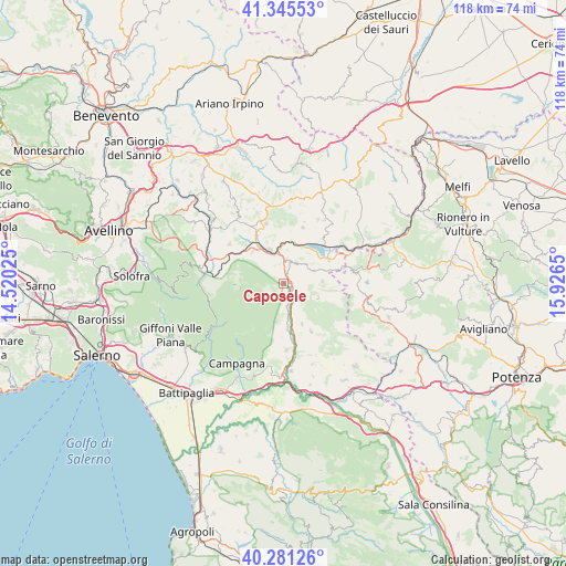
Caposele GPS coordinates[2]
40° 48' 55.908" North, 15° 13' 24.132" East
| Map corner | latitude | longitude |
|---|---|---|
| Upper-left | 41.34553°, | 14.52025° |
| Center: | 40.81553°, | 15.22337° |
| Lower-right: | 40.28126°, | 15.9265° |
| Map W x H: | 118.3×118.3 km | = 73.5×73.5mi |
| max Lat: | 47.04031° ⇑81.2% North |
| Caposele: | 40.81553° |
| min Lat: | ⇓18.8% South 35.50142° |
| min Long | Caposele | max Long |
| 6.69888° | 15.22337° | 18.48682° |
| W 89%⇐ | ⇒11% E |
Elevation
Elevation of Caposele is 401 m = 1316 ft, and this is 94.3 m = 309 ft above average elevation for this country.
| Max E: |
2085 m = 6841 ft | 29.2% |
| Caposele | 401 m 1316 ft | |
| Avg. | 306.7 m = 1006 ft | |
Min E: |
-4 m = -13 ft | 70.8% |
See also: Italy elevation on elevation.city.
Geographical zone
Caposele is located in North temperate zone (between Tropic of Cancer and the Arctic Circle). Distance of this Northern Tropic circle is 1932.3 km =1200.7 mi to South.| Distance of | km | miles | from Caposele |
|---|---|---|---|
| North Pole | 5468.8 | 3398.2 | to North |
| Arctic Circle | 2862.9 | 1778.9 | to North |
| Tropic Cancer | 1932.3 | 1200.7 | to South |
| Equator | 4538.3 | 2820 | to South |


Nearby cities:
15 places around Caposele: (largest is in red/bold)
• Calabritto
3.6 km =2.2 mi,  180°
180°
• Castelnuovo di Conza
8 km =5 mi,  85°
85°
• Centro Urbano
8.1 km =5 mi, 86°
• Colliano
11.7 km =7.3 mi,  151°
151°
• Laviano
7.8 km =4.8 mi,  114°
114°
• Lioni
8 km =5 mi,  335°
335°
• Materdomini
1.1 km =0.7 mi,  75°
75°
• Morra de Sanctis
12.7 km =7.9 mi,  7°
7°
• Nuova Conza della Campania
10.7 km =6.6 mi,  63°
63°
• Piani
0.6 km =0.4 mi,  50°
50°
• Sant'Andrea di Conza
12.7 km =7.9 mi, 75°
• Santomenna
8.7 km =5.4 mi,  96°
96°
• Senerchia
8.4 km =5.2 mi,  190°
190°
• Teora
4.9 km =3 mi,  31°
31°
• Valva
9.3 km =5.8 mi,  156°
156°
Sources, notices
• [Note1] Compared only with cities in Italy existing in our database
• [Src1] Map data: © OpenStreetMap contributors (CC-BY-SA)
• [Src2] Other city data from geonames.org with taken over terms of usage.
• [Src3] Geographical zone / Annual Mean Temperature by Robert A. Rohde @ Wikipedia
