Canzo geodata
Canzo (Lombardy) is a seat of a third-order administrative division; located in Italy in Europe/Rome (GMT+2) time zone. With population of 5,109 people, there are 1917 cities with bigger population in this country. Compared to other cities in Italy, 87.6% of cities are located further ↓South; 77% of cities are located further →East and 69.9% of cities have lower elevation than Canzo. Note1


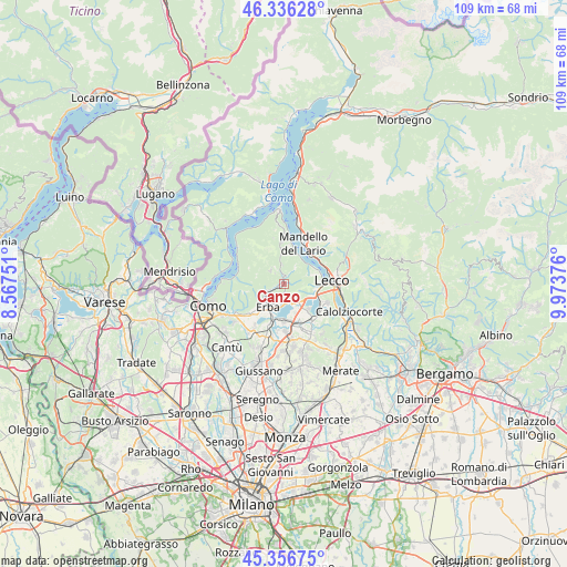
Canzo GPS coordinates[2]
45° 50' 55.212" North, 9° 16' 14.268" East
| Map corner | latitude | longitude |
|---|---|---|
| Upper-left | 46.33628°, | 8.56751° |
| Center: | 45.84867°, | 9.27063° |
| Lower-right: | 45.35675°, | 9.97376° |
| Map W x H: | 108.9×108.9 km | = 67.7×67.7mi |
| max Lat: | 47.04031° ⇑12.4% North |
| Canzo: | 45.84867° |
| min Lat: | ⇓87.6% South 35.50142° |
| min Long | Canzo | max Long |
| 6.69888° | 9.27063° | 18.48682° |
| W 23%⇐ | ⇒77% E |
Elevation
Elevation of Canzo is 393 m = 1289 ft, and this is 86.3 m = 283 ft above average elevation for this country.
| Max E: |
2085 m = 6841 ft | 30.1% |
| Canzo | 393 m 1289 ft | |
| Avg. | 306.7 m = 1006 ft | |
Min E: |
-4 m = -13 ft | 69.9% |
See also: Italy elevation on elevation.city.
Geographical zone
Canzo is located in North temperate zone (between Tropic of Cancer and the Arctic Circle). Distance of this North polar circle is 2303.3 km =1431.2 mi to North.| Distance of | km | miles | from Canzo |
|---|---|---|---|
| North Pole | 4909.2 | 3050.4 | to North |
| Arctic Circle | 2303.3 | 1431.2 | to North |
| Tropic Cancer | 2492 | 1548.5 | to South |
| Equator | 5097.9 | 3167.7 | to South |


Nearby cities:
15 places around Canzo: (largest is in red/bold)
• Asso
1.4 km =0.9 mi,  349°
349°
• Caglio
3.6 km =2.2 mi,  314°
314°
• Caslino d'Erba
3.7 km =2.3 mi,  252°
252°
• Castelmarte
3.4 km =2.1 mi,  238°
238°
• Cesana Brianza
4.2 km =2.6 mi,  147°
147°
• Corneno-Galliano-Carella Mariaga
3.6 km =2.2 mi,  184°
184°
• Lasnigo
3.7 km =2.3 mi, 354°
• Longone al Segrino
4.1 km =2.5 mi,  201°
201°
• Osigo
3.5 km =2.2 mi,  33°
33°
• Penzano
4.4 km =2.7 mi,  192°
192°
• Proserpio
3 km =1.9 mi,  220°
220°
• Pusiano
3.9 km =2.4 mi,  166°
166°
• Rezzago
2.6 km =1.6 mi,  319°
319°
• Sormano
3.8 km =2.4 mi,  329°
329°
• Valbrona
3.9 km =2.4 mi, 34°
Sources, notices
• [Note1] Compared only with cities in Italy existing in our database
• [Src1] Map data: © OpenStreetMap contributors (CC-BY-SA)
• [Src2] Other city data from geonames.org with taken over terms of usage.
• [Src3] Geographical zone / Annual Mean Temperature by Robert A. Rohde @ Wikipedia
