Longone al Segrino geodata
Longone al Segrino (Lombardy) is a seat of a third-order administrative division; located in Italy in Europe/Rome (GMT+2) time zone. With population of 1,753 people, there are 4566 cities with bigger population in this country. Compared to other cities in Italy, 86.4% of cities are located further ↓South; 77.3% of cities are located further →East and 67.5% of cities have lower elevation than Longone al Segrino. Note1
Administrative division(s):
- Level 1: Lombardy
- Level 2: Provincia di Como
- Level 3: Longone al Segrino


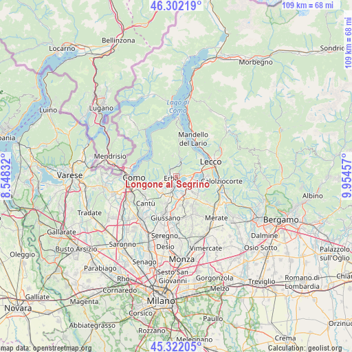
Longone al Segrino GPS coordinates[2]
45° 48' 51.408" North, 9° 15' 5.184" East
| Map corner | latitude | longitude |
|---|---|---|
| Upper-left | 46.30219°, | 8.54832° |
| Center: | 45.81428°, | 9.25144° |
| Lower-right: | 45.32205°, | 9.95457° |
| Map W x H: | 109×109 km | = 67.7×67.7mi |
| max Lat: | 47.04031° ⇑13.6% North |
| Longone al Segrino: | 45.81428° |
| min Lat: | ⇓86.4% South 35.50142° |
| min Long | Longone al Segr | max Long |
| 6.69888° | 9.25144° | 18.48682° |
| W 22.7%⇐ | ⇒77.3% E |
Elevation
Elevation of Longone al Segrino is 368 m = 1207 ft, and this is 61.3 m = 201 ft above average elevation for this country.
| Max E: |
2085 m = 6841 ft | 32.5% |
| Longone al Segrino | 368 m 1207 ft | |
| Avg. | 306.7 m = 1006 ft | |
Min E: |
-4 m = -13 ft | 67.5% |
See also: Italy elevation on elevation.city.
Geographical zone
Longone al Segrino is located in North temperate zone (between Tropic of Cancer and the Arctic Circle). Distance of this North polar circle is 2307.1 km =1433.6 mi to North.| Distance of | km | miles | from Longone al Segrino |
|---|---|---|---|
| North Pole | 4913 | 3052.8 | to North |
| Arctic Circle | 2307.1 | 1433.6 | to North |
| Tropic Cancer | 2488.2 | 1546.1 | to South |
| Equator | 5094.1 | 3165.3 | to South |


Nearby cities:
15 places around Longone al Segrino: (largest is in red/bold)
• Bosisio Parini
3.3 km =2.1 mi,  116°
116°
• Canzo
4.1 km =2.5 mi,  21°
21°
• Caslino d'Erba
3.4 km =2.1 mi,  323°
323°
• Castelmarte
2.5 km =1.6 mi, 324°
• Cesana Brianza
3.7 km =2.3 mi,  85°
85°
• Corneno-Galliano-Carella Mariaga
1.2 km =0.7 mi,  77°
77°
• Erba
2.1 km =1.3 mi,  252°
252°
• Merone
3.1 km =1.9 mi,  190°
190°
• Nobile-Monguzzo
4.1 km =2.5 mi,  203°
203°
• Penzano
0.7 km =0.4 mi,  130°
130°
• Ponte Lambro
2.4 km =1.5 mi,  300°
300°
• Proserpio
1.6 km =1 mi,  343°
343°
• Pusiano
2.4 km =1.5 mi, 88°
• Rogeno
4 km =2.5 mi,  153°
153°
• Suello
4.7 km =2.9 mi, 86°
Sources, notices
• [Note1] Compared only with cities in Italy existing in our database
• [Src1] Map data: © OpenStreetMap contributors (CC-BY-SA)
• [Src2] Other city data from geonames.org with taken over terms of usage.
• [Src3] Geographical zone / Annual Mean Temperature by Robert A. Rohde @ Wikipedia
