Canna geodata
Canna (Calabria) is a seat of a third-order administrative division; located in Italy in Europe/Rome (GMT+2) time zone. With population of 771 people, there are 7811 cities with bigger population in this country. Compared to other cities in Italy, 87.2% of cities are located further ↑North; 96.4% of cities are located further ←West and 70.9% of cities have lower elevation than Canna. Note1


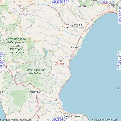
Canna GPS coordinates[2]
40° 5' 41.424" North, 16° 30' 13.608" East
| Map corner | latitude | longitude |
|---|---|---|
| Upper-left | 40.63059°, | 15.80066° |
| Center: | 40.09484°, | 16.50378° |
| Lower-right: | 39.55484°, | 17.20691° |
| Map W x H: | 119.6×119.6 km | = 74.3×74.3mi |
| max Lat: | 47.04031° ⇑87.2% North |
| Canna: | 40.09484° |
| min Lat: | ⇓12.8% South 35.50142° |
| min Long | Canna | max Long |
| 6.69888° | 16.50378° | 18.48682° |
| W 96.4%⇐ | ⇒3.6% E |
Elevation
Elevation of Canna is 403 m = 1322 ft, and this is 96.3 m = 316 ft above average elevation for this country.
| Max E: |
2085 m = 6841 ft | 29.1% |
| Canna | 403 m 1322 ft | |
| Avg. | 306.7 m = 1006 ft | |
Min E: |
-4 m = -13 ft | 70.9% |
See also: Italy elevation on elevation.city.
Geographical zone
Canna is located in North temperate zone (between Tropic of Cancer and the Arctic Circle). Distance of this Northern Tropic circle is 1852.2 km =1150.9 mi to South.| Distance of | km | miles | from Canna |
|---|---|---|---|
| North Pole | 5548.9 | 3447.9 | to North |
| Arctic Circle | 2943 | 1828.7 | to North |
| Tropic Cancer | 1852.2 | 1150.9 | to South |
| Equator | 4458.1 | 2770.1 | to South |


Nearby cities:
15 places around Canna: (largest is in red/bold)
• Castroregio
11.6 km =7.2 mi,  190°
190°
• Cersosimo
14.1 km =8.8 mi,  247°
247°
• Colobraro
12.4 km =7.7 mi,  327°
327°
• Marina
10.5 km =6.5 mi,  129°
129°
• Montegiordano
6.3 km =3.9 mi,  155°
155°
• Nocara
1.9 km =1.2 mi,  285°
285°
• Nova Siri
6.7 km =4.2 mi,  27°
27°
• Nova Siri Scalo
12 km =7.5 mi,  69°
69°
• Oriolo
6.7 km =4.2 mi,  226°
226°
• Rocca Imperiale
6.6 km =4.1 mi, 74°
• Rocca Imperiale Marina
9.3 km =5.8 mi,  86°
86°
• Roseto Capo Spulico
14.7 km =9.1 mi,  144°
144°
• Rotondella
8.7 km =5.4 mi,  11°
11°
• San Giorgio Lucano
9.9 km =6.2 mi,  280°
280°
• Valsinni
9.9 km =6.2 mi, 328°
Sources, notices
• [Note1] Compared only with cities in Italy existing in our database
• [Src1] Map data: © OpenStreetMap contributors (CC-BY-SA)
• [Src2] Other city data from geonames.org with taken over terms of usage.
• [Src3] Geographical zone / Annual Mean Temperature by Robert A. Rohde @ Wikipedia
