Rotondella geodata
Rotondella (Basilicate) is a seat of a third-order administrative division; located in Italy in Europe/Rome (GMT+2) time zone. With population of 1,467 people, there are 5203 cities with bigger population in this country. Compared to other cities in Italy, 86.6% of cities are located further ↑North; 96.6% of cities are located further ←West and 82.4% of cities have lower elevation than Rotondella. Note1


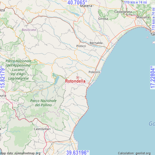
Rotondella GPS coordinates[2]
40° 10' 16.896" North, 16° 31' 29.676" East
| Map corner | latitude | longitude |
|---|---|---|
| Upper-left | 40.7065°, | 15.82179° |
| Center: | 40.17136°, | 16.52491° |
| Lower-right: | 39.63196°, | 17.22804° |
| Map W x H: | 119.5×119.5 km | = 74.3×74.3mi |
| max Lat: | 47.04031° ⇑86.6% North |
| Rotondella: | 40.17136° |
| min Lat: | ⇓13.4% South 35.50142° |
| min Long | Rotondella | max Long |
| 6.69888° | 16.52491° | 18.48682° |
| W 96.6%⇐ | ⇒3.4% E |
Elevation
Elevation of Rotondella is 562 m = 1844 ft, and this is 255.3 m = 838 ft above average elevation for this country.
| Max E: |
2085 m = 6841 ft | 17.6% |
| Rotondella | 562 m 1844 ft | |
| Avg. | 306.7 m = 1006 ft | |
Min E: |
-4 m = -13 ft | 82.4% |
See also: Italy elevation on elevation.city.
Geographical zone
Rotondella is located in North temperate zone (between Tropic of Cancer and the Arctic Circle). Distance of this Northern Tropic circle is 1860.7 km =1156.2 mi to South.| Distance of | km | miles | from Rotondella |
|---|---|---|---|
| North Pole | 5540.4 | 3442.6 | to North |
| Arctic Circle | 2934.5 | 1823.4 | to North |
| Tropic Cancer | 1860.7 | 1156.2 | to South |
| Equator | 4466.6 | 2775.4 | to South |


Nearby cities:
15 places around Rotondella: (largest is in red/bold)
• Canna
8.7 km =5.4 mi,  191°
191°
• Colobraro
8.7 km =5.4 mi,  282°
282°
• Lido
15.6 km =9.7 mi,  81°
81°
• Montalbano Jonico
13.3 km =8.3 mi,  16°
16°
• Montegiordano
14.3 km =8.9 mi,  176°
176°
• Nocara
8.8 km =5.5 mi,  204°
204°
• Nova Siri
2.9 km =1.8 mi,  153°
153°
• Nova Siri Scalo
10.4 km =6.5 mi,  115°
115°
• Oriolo
14.7 km =9.1 mi,  206°
206°
• Policoro
13.8 km =8.6 mi,  70°
70°
• Rocca Imperiale
8.2 km =5.1 mi, 146°
• Rocca Imperiale Marina
11 km =6.8 mi,  136°
136°
• San Giorgio Lucano
13.3 km =8.3 mi,  239°
239°
• Tursi
9.5 km =5.9 mi,  331°
331°
• Valsinni
6.9 km =4.3 mi,  269°
269°
Sources, notices
• [Note1] Compared only with cities in Italy existing in our database
• [Src1] Map data: © OpenStreetMap contributors (CC-BY-SA)
• [Src2] Other city data from geonames.org with taken over terms of usage.
• [Src3] Geographical zone / Annual Mean Temperature by Robert A. Rohde @ Wikipedia
