Calvanico geodata
Calvanico (Campania) is a seat of a third-order administrative division; located in Italy in Europe/Rome (GMT+2) time zone. With population of 1,570 people, there are 4958 cities with bigger population in this country. Compared to other cities in Italy, 81.6% of cities are located further ↑North; 85.7% of cities are located further ←West and 78.4% of cities have lower elevation than Calvanico. Note1


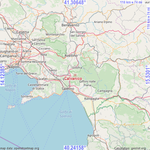
Calvanico GPS coordinates[2]
40° 46' 34.176" North, 14° 49' 37.092" East
| Map corner | latitude | longitude |
|---|---|---|
| Upper-left | 41.30648°, | 14.12385° |
| Center: | 40.77616°, | 14.82697° |
| Lower-right: | 40.24158°, | 15.5301° |
| Map W x H: | 118.4×118.4 km | = 73.6×73.6mi |
| max Lat: | 47.04031° ⇑81.6% North |
| Calvanico: | 40.77616° |
| min Lat: | ⇓18.4% South 35.50142° |
| min Long | Calvanico | max Long |
| 6.69888° | 14.82697° | 18.48682° |
| W 85.7%⇐ | ⇒14.3% E |
Elevation
Elevation of Calvanico is 499 m = 1637 ft, and this is 192.3 m = 631 ft above average elevation for this country.
| Max E: |
2085 m = 6841 ft | 21.6% |
| Calvanico | 499 m 1637 ft | |
| Avg. | 306.7 m = 1006 ft | |
Min E: |
-4 m = -13 ft | 78.4% |
See also: Italy elevation on elevation.city.
Geographical zone
Calvanico is located in North temperate zone (between Tropic of Cancer and the Arctic Circle). Distance of this Northern Tropic circle is 1928 km =1198 mi to South.| Distance of | km | miles | from Calvanico |
|---|---|---|---|
| North Pole | 5473.2 | 3400.9 | to North |
| Arctic Circle | 2867.3 | 1781.7 | to North |
| Tropic Cancer | 1928 | 1198 | to South |
| Equator | 4533.9 | 2817.2 | to South |


Nearby cities:
15 places around Calvanico: (largest is in red/bold)
• Baronissi
5.5 km =3.4 mi,  235°
235°
• Caprecano
4.9 km =3 mi,  218°
218°
• Castiglione del Genovesi
6.1 km =3.8 mi,  163°
163°
• Faraldo-Nocelleto
5.3 km =3.3 mi,  274°
274°
• Fisciano
2.8 km =1.7 mi,  259°
259°
• Gaiano
2.5 km =1.6 mi,  200°
200°
• Lancusi-Penta-Bolano
3.9 km =2.4 mi, 244°
• Le Selve
3.9 km =2.4 mi, 267°
• Misciano
5.5 km =3.4 mi,  321°
321°
• Montoro Superiore
5.1 km =3.2 mi,  332°
332°
• Piazza di Pandola
5.8 km =3.6 mi,  306°
306°
• Pizzolano
3.9 km =2.4 mi,  280°
280°
• Soccorso
5 km =3.1 mi,  296°
296°
• Torchiati
5.2 km =3.2 mi,  335°
335°
• Villa
3.3 km =2.1 mi,  292°
292°
Sources, notices
• [Note1] Compared only with cities in Italy existing in our database
• [Src1] Map data: © OpenStreetMap contributors (CC-BY-SA)
• [Src2] Other city data from geonames.org with taken over terms of usage.
• [Src3] Geographical zone / Annual Mean Temperature by Robert A. Rohde @ Wikipedia
