Villa geodata
Villa (Campania) is a populated place; located in Italy in Europe/Rome (GMT+2) time zone. With population of 867 people, there are 7328 cities with bigger population in this country. Compared to other cities in Italy, 81.5% of cities are located further ↑North; 85.4% of cities are located further ←West and 60% of cities have lower elevation than Villa. Note1


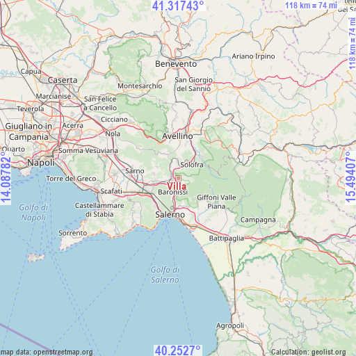
Villa GPS coordinates[2]
40° 47' 13.92" North, 14° 47' 27.384" East
| Map corner | latitude | longitude |
|---|---|---|
| Upper-left | 41.31743°, | 14.08782° |
| Center: | 40.7872°, | 14.79094° |
| Lower-right: | 40.2527°, | 15.49407° |
| Map W x H: | 118.4×118.4 km | = 73.6×73.6mi |
| max Lat: | 47.04031° ⇑81.5% North |
| Villa: | 40.7872° |
| min Lat: | ⇓18.5% South 35.50142° |
| min Long | Villa | max Long |
| 6.69888° | 14.79094° | 18.48682° |
| W 85.4%⇐ | ⇒14.6% E |
Elevation
Elevation of Villa is 299 m = 981 ft, and this is 7.7 m = 25 ft below average elevation for this country.
| Max E: |
2085 m = 6841 ft | 40% |
| Avg. | 306.7 m = 1006 ft | |
| Villa | 299 m = 981 ft | |
Min E: |
-4 m = -13 ft | 60% |
See also: Italy elevation on elevation.city.
Geographical zone
Villa is located in North temperate zone (between Tropic of Cancer and the Arctic Circle). Distance of this Northern Tropic circle is 1929.2 km =1198.7 mi to South.| Distance of | km | miles | from Villa |
|---|---|---|---|
| North Pole | 5472 | 3400.1 | to North |
| Arctic Circle | 2866.1 | 1780.9 | to North |
| Tropic Cancer | 1929.2 | 1198.7 | to South |
| Equator | 4535.1 | 2818 | to South |


Nearby cities:
15 places around Villa: (largest is in red/bold)
• Calvanico
3.3 km =2.1 mi,  112°
112°
• Faraldo-Nocelleto
2.4 km =1.5 mi,  250°
250°
• Fisciano
1.7 km =1.1 mi,  169°
169°
• Gaiano
4.2 km =2.6 mi,  149°
149°
• Lancusi-Penta-Bolano
2.9 km =1.8 mi,  189°
189°
• Le Selve
1.7 km =1.1 mi,  210°
210°
• Mercato San Severino
3.1 km =1.9 mi,  264°
264°
• Misciano
3.1 km =1.9 mi,  352°
352°
• Montoro Superiore
3.4 km =2.1 mi,  10°
10°
• Piazza di Pandola
2.8 km =1.7 mi,  324°
324°
• Pizzolano
0.9 km =0.6 mi,  235°
235°
• San Pietro
4.1 km =2.5 mi, 352°
• Soccorso
1.8 km =1.1 mi,  305°
305°
• Spiano
4.5 km =2.8 mi,  230°
230°
• Torchiati
3.6 km =2.2 mi, 14°
Sources, notices
• [Note1] Compared only with cities in Italy existing in our database
• [Src1] Map data: © OpenStreetMap contributors (CC-BY-SA)
• [Src2] Other city data from geonames.org with taken over terms of usage.
• [Src3] Geographical zone / Annual Mean Temperature by Robert A. Rohde @ Wikipedia
