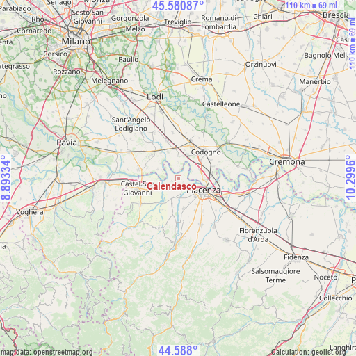
Calendasco geodata
Calendasco (Emilia-Romagna) is a seat of a third-order administrative division; located in Italy in Europe/Rome (GMT+2) time zone. With population of 781 people, there are 7747 cities with bigger population in this country. Compared to other cities in Italy, 62.1% of cities are located further ↓South; 72% of cities are located further →East and 79.6% of cities have higher elevation than Calendasco. Note1
Administrative division(s):
- Level 1: Emilia-Romagna
- Level 2: Provincia di Piacenza
- Level 3: Calendasco


Calendasco GPS coordinates[2]
45° 5' 11.724" North, 9° 35' 47.292" East
| Map corner | latitude | longitude |
|---|---|---|
| Upper-left | 45.58087°, | 8.89334° |
| Center: | 45.08659°, | 9.59647° |
| Lower-right: | 44.588°, | 10.2996° |
| Map W x H: | 110.4×110.4 km | = 68.6×68.6mi |
| max Lat: | 47.04031° ⇑37.9% North |
| Calendasco: | 45.08659° |
| min Lat: | ⇓62.1% South 35.50142° |
| min Long | Calendasco | max Long |
| 6.69888° | 9.59647° | 18.48682° |
| W 28%⇐ | ⇒72% E |
Elevation
Elevation of Calendasco is 52 m = 171 ft, and this is 254.7 m = 836 ft below average elevation for this country.
| Max E: |
2085 m = 6841 ft | 79.6% |
| Avg. | 306.7 m = 1006 ft | |
| Calendasco | 52 m = 171 ft | |
Min E: |
-4 m = -13 ft | 20.4% |
See also: Italy elevation on elevation.city.
Geographical zone
Calendasco is located in North temperate zone (between Tropic of Cancer and the Arctic Circle). Distance of this North polar circle is 2388 km =1483.8 mi to North.| Distance of | km | miles | from Calendasco |
|---|---|---|---|
| North Pole | 4993.9 | 3103.1 | to North |
| Arctic Circle | 2388 | 1483.8 | to North |
| Tropic Cancer | 2407.2 | 1495.8 | to South |
| Equator | 5013.2 | 3115.1 | to South |


Nearby cities:
15 places around Calendasco: (largest is in red/bold)
• Fombio
9 km =5.6 mi,  47°
47°
• Gragnano Trebbiense
8.5 km =5.3 mi,  193°
193°
• Guardamiglio
7.3 km =4.5 mi,  71°
71°
• Mirabello
7.2 km =4.5 mi,  10°
10°
• Monticelli Pavese
7.1 km =4.4 mi,  292°
292°
• Orio Litta
9.1 km =5.7 mi,  338°
338°
• Ospedaletto Lodigiano
9.2 km =5.7 mi,  351°
351°
• Piacenza
8.5 km =5.3 mi,  116°
116°
• Rottofreno
5 km =3.1 mi,  226°
226°
• San Martino Pizzolano
8.8 km =5.5 mi, 12°
• San Nicolò
3.4 km =2.1 mi,  168°
168°
• San Rocco al Porto
7.9 km =4.9 mi,  93°
93°
• Sarmato
8.5 km =5.3 mi,  247°
247°
• Senna Lodigiana
7.1 km =4.4 mi,  358°
358°
• Somaglia
7.6 km =4.7 mi,  22°
22°
Sources, notices
• [Note1] Compared only with cities in Italy existing in our database
• [Src1] Map data: © OpenStreetMap contributors (CC-BY-SA)
• [Src2] Other city data from geonames.org with taken over terms of usage.
• [Src3] Geographical zone / Annual Mean Temperature by Robert A. Rohde @ Wikipedia
