Monticelli Pavese geodata
Monticelli Pavese (Lombardy) is a seat of a third-order administrative division; located in Italy in Europe/Rome (GMT+2) time zone. With population of 458 people, there are 10058 cities with bigger population in this country. Compared to other cities in Italy, 62.7% of cities are located further ↓South; 73.1% of cities are located further →East and 79.6% of cities have higher elevation than Monticelli Pavese. Note1
Administrative division(s):
- Level 1: Lombardy
- Level 2: Provincia di Pavia
- Level 3: Monticelli Pavese


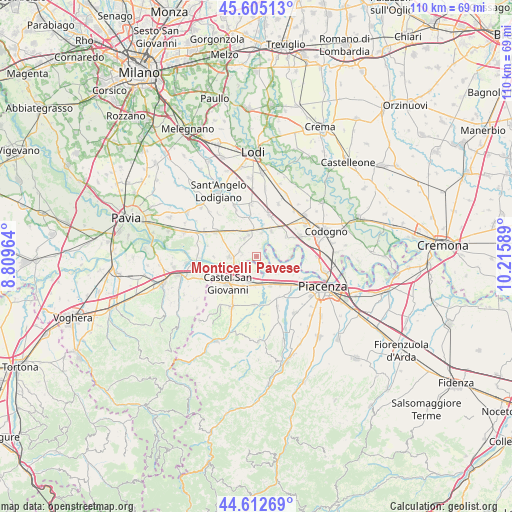
Monticelli Pavese GPS coordinates[2]
45° 6' 39.852" North, 9° 30' 45.936" East
| Map corner | latitude | longitude |
|---|---|---|
| Upper-left | 45.60513°, | 8.80964° |
| Center: | 45.11107°, | 9.51276° |
| Lower-right: | 44.61269°, | 10.21589° |
| Map W x H: | 110.3×110.3 km | = 68.5×68.5mi |
| max Lat: | 47.04031° ⇑37.3% North |
| Monticelli Pavese: | 45.11107° |
| min Lat: | ⇓62.7% South 35.50142° |
| min Long | Monticelli Pave | max Long |
| 6.69888° | 9.51276° | 18.48682° |
| W 26.9%⇐ | ⇒73.1% E |
Elevation
Elevation of Monticelli Pavese is 52 m = 171 ft, and this is 254.7 m = 836 ft below average elevation for this country.
| Max E: |
2085 m = 6841 ft | 79.6% |
| Avg. | 306.7 m = 1006 ft | |
| Monticelli Pavese | 52 m = 171 ft | |
Min E: |
-4 m = -13 ft | 20.4% |
See also: Italy elevation on elevation.city.
Geographical zone
Monticelli Pavese is located in North temperate zone (between Tropic of Cancer and the Arctic Circle). Distance of this North polar circle is 2385.3 km =1482.2 mi to North.| Distance of | km | miles | from Monticelli Pavese |
|---|---|---|---|
| North Pole | 4991.2 | 3101.4 | to North |
| Arctic Circle | 2385.3 | 1482.2 | to North |
| Tropic Cancer | 2410 | 1497.5 | to South |
| Equator | 5015.9 | 3116.7 | to South |


Nearby cities:
15 places around Monticelli Pavese: (largest is in red/bold)
• Badia Pavese
3.6 km =2.2 mi,  287°
287°
• Calendasco
7.1 km =4.4 mi,  112°
112°
• Camporinaldo
6.7 km =4.2 mi,  330°
330°
• Castel San Giovanni
8.2 km =5.1 mi,  226°
226°
• Chignolo Po
4.8 km =3 mi, 329°
• Fontana Pradosa
6.8 km =4.2 mi,  215°
215°
• Lambrinia
5.4 km =3.4 mi,  12°
12°
• Miradolo Terme
8.5 km =5.3 mi,  321°
321°
• Orio Litta
6.6 km =4.1 mi,  29°
29°
• Ospedaletto Lodigiano
8.2 km =5.1 mi,  38°
38°
• Pieve Porto Morone
5.7 km =3.5 mi,  268°
268°
• Rottofreno
6.9 km =4.3 mi,  154°
154°
• San Colombano al Lambro
8.2 km =5.1 mi,  347°
347°
• Sarmato
6.2 km =3.9 mi,  191°
191°
• Senna Lodigiana
7.7 km =4.8 mi,  55°
55°
Sources, notices
• [Note1] Compared only with cities in Italy existing in our database
• [Src1] Map data: © OpenStreetMap contributors (CC-BY-SA)
• [Src2] Other city data from geonames.org with taken over terms of usage.
• [Src3] Geographical zone / Annual Mean Temperature by Robert A. Rohde @ Wikipedia
