Cagnola geodata
Cagnola (Veneto) is a populated place; located in Italy in Europe/Rome (GMT+2) time zone. With population of 803 people, there are 7629 cities with bigger population in this country. Compared to other cities in Italy, 67% of cities are located further ↓South; 54.1% of cities are located further ←West and 97.2% of cities have higher elevation than Cagnola. Note1


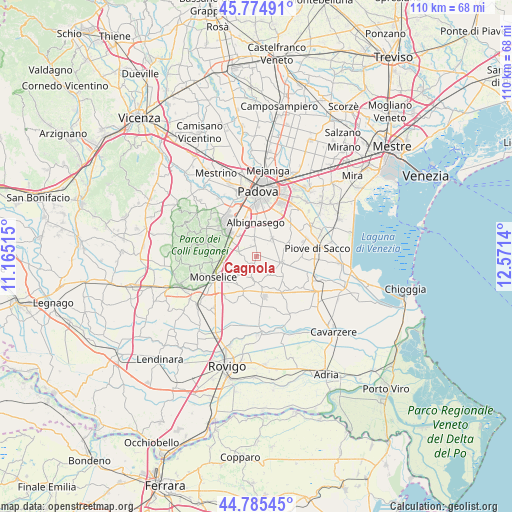
Cagnola GPS coordinates[2]
45° 16' 56.424" North, 11° 52' 5.772" East
| Map corner | latitude | longitude |
|---|---|---|
| Upper-left | 45.77491°, | 11.16515° |
| Center: | 45.28234°, | 11.86827° |
| Lower-right: | 44.78545°, | 12.5714° |
| Map W x H: | 110×110 km | = 68.4×68.4mi |
| max Lat: | 47.04031° ⇑33% North |
| Cagnola: | 45.28234° |
| min Lat: | ⇓67% South 35.50142° |
| min Long | Cagnola | max Long |
| 6.69888° | 11.86827° | 18.48682° |
| W 54.1%⇐ | ⇒45.9% E |
Elevation
Elevation of Cagnola is 5 m = 16 ft, and this is 301.7 m = 990 ft below average elevation for this country.
| Max E: |
2085 m = 6841 ft | 97.2% |
| Avg. | 306.7 m = 1006 ft | |
| Cagnola | 5 m = 16 ft | |
Min E: |
-4 m = -13 ft | 2.8% |
See also: Italy elevation on elevation.city.
Geographical zone
Cagnola is located in North temperate zone (between Tropic of Cancer and the Arctic Circle). Distance of this North polar circle is 2366.2 km =1470.3 mi to North.| Distance of | km | miles | from Cagnola |
|---|---|---|---|
| North Pole | 4972.1 | 3089.5 | to North |
| Arctic Circle | 2366.2 | 1470.3 | to North |
| Tropic Cancer | 2429 | 1509.3 | to South |
| Equator | 5034.9 | 3128.5 | to South |


Nearby cities:
15 places around Cagnola: (largest is in red/bold)
• Battaglia Terme
6.6 km =4.1 mi,  272°
272°
• Bertipaglia
4 km =2.5 mi,  19°
19°
• Bovolenta
5.5 km =3.4 mi,  105°
105°
• Carrara San Giorgio
4.1 km =2.5 mi,  286°
286°
• Cartura
1.8 km =1.1 mi,  210°
210°
• Casalserugo
5 km =3.1 mi,  43°
43°
• Conselve
5.7 km =3.5 mi,  174°
174°
• Cornegliana
2.5 km =1.6 mi,  332°
332°
• Due Carrare
3.6 km =2.2 mi, 286°
• Maserà di Padova
4 km =2.5 mi,  356°
356°
• Mezzavia
6.3 km =3.9 mi,  314°
314°
• Pernumia
6.9 km =4.3 mi,  247°
247°
• San Pietro Viminario
5.6 km =3.5 mi,  222°
222°
• Terradura
5.7 km =3.5 mi,  322°
322°
• Terrassa Padovana
5 km =3.1 mi,  147°
147°
Sources, notices
• [Note1] Compared only with cities in Italy existing in our database
• [Src1] Map data: © OpenStreetMap contributors (CC-BY-SA)
• [Src2] Other city data from geonames.org with taken over terms of usage.
• [Src3] Geographical zone / Annual Mean Temperature by Robert A. Rohde @ Wikipedia
