Cartura geodata
Cartura (Veneto) is a seat of a third-order administrative division; located in Italy in Europe/Rome (GMT+2) time zone. With population of 2,094 people, there are 3998 cities with bigger population in this country. Compared to other cities in Italy, 66.6% of cities are located further ↓South; 53.9% of cities are located further ←West and 97.8% of cities have higher elevation than Cartura. Note1


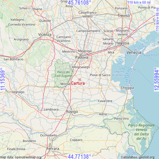
Cartura GPS coordinates[2]
45° 16' 6.204" North, 11° 51' 24.516" East
| Map corner | latitude | longitude |
|---|---|---|
| Upper-left | 45.76108°, | 11.15369° |
| Center: | 45.26839°, | 11.85681° |
| Lower-right: | 44.77138°, | 12.55994° |
| Map W x H: | 110×110 km | = 68.4×68.4mi |
| max Lat: | 47.04031° ⇑33.4% North |
| Cartura: | 45.26839° |
| min Lat: | ⇓66.6% South 35.50142° |
| min Long | Cartura | max Long |
| 6.69888° | 11.85681° | 18.48682° |
| W 53.9%⇐ | ⇒46.1% E |
Elevation
Elevation of Cartura is 4 m = 13 ft, and this is 302.7 m = 993 ft below average elevation for this country.
| Max E: |
2085 m = 6841 ft | 97.8% |
| Avg. | 306.7 m = 1006 ft | |
| Cartura | 4 m = 13 ft | |
Min E: |
-4 m = -13 ft | 2.2% |
See also: Italy elevation on elevation.city.
Geographical zone
Cartura is located in North temperate zone (between Tropic of Cancer and the Arctic Circle). Distance of this North polar circle is 2367.8 km =1471.3 mi to North.| Distance of | km | miles | from Cartura |
|---|---|---|---|
| North Pole | 4973.7 | 3090.5 | to North |
| Arctic Circle | 2367.8 | 1471.3 | to North |
| Tropic Cancer | 2427.5 | 1508.4 | to South |
| Equator | 5033.4 | 3127.6 | to South |


Nearby cities:
15 places around Cartura: (largest is in red/bold)
• Battaglia Terme
6 km =3.7 mi,  288°
288°
• Bertipaglia
5.7 km =3.5 mi,  22°
22°
• Bovolenta
6.2 km =3.9 mi,  89°
89°
• Cagnola
1.8 km =1.1 mi,  30°
30°
• Carrara San Giorgio
4 km =2.5 mi,  311°
311°
• Casalserugo
6.8 km =4.2 mi,  39°
39°
• Conselve
4.3 km =2.7 mi,  160°
160°
• Cornegliana
3.8 km =2.4 mi,  355°
355°
• Due Carrare
3.6 km =2.2 mi,  315°
315°
• Maserà di Padova
5.6 km =3.5 mi,  6°
6°
• Pernumia
5.5 km =3.4 mi,  259°
259°
• San Pietro Viminario
3.9 km =2.4 mi,  227°
227°
• Terradura
6.6 km =4.1 mi,  337°
337°
• Terrassa Padovana
4.5 km =2.8 mi,  126°
126°
• Tribano
6.8 km =4.2 mi,  193°
193°
Sources, notices
• [Note1] Compared only with cities in Italy existing in our database
• [Src1] Map data: © OpenStreetMap contributors (CC-BY-SA)
• [Src2] Other city data from geonames.org with taken over terms of usage.
• [Src3] Geographical zone / Annual Mean Temperature by Robert A. Rohde @ Wikipedia
