Bucchianico geodata
Bucchianico (Abruzzo) is a seat of a third-order administrative division; located in Italy in Europe/Rome (GMT+2) time zone. With population of 1,702 people, there are 4662 cities with bigger population in this country. Compared to other cities in Italy, 67.7% of cities are located further ↑North; 79.6% of cities are located further ←West and 60.2% of cities have lower elevation than Bucchianico. Note1


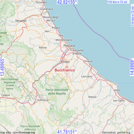
Bucchianico GPS coordinates[2]
42° 18' 13.248" North, 14° 11' 1.572" East
| Map corner | latitude | longitude |
|---|---|---|
| Upper-left | 42.82155°, | 13.48065° |
| Center: | 42.30368°, | 14.18377° |
| Lower-right: | 41.78151°, | 14.8869° |
| Map W x H: | 115.6×115.6 km | = 71.8×71.8mi |
| max Lat: | 47.04031° ⇑67.7% North |
| Bucchianico: | 42.30368° |
| min Lat: | ⇓32.3% South 35.50142° |
| min Long | Bucchianico | max Long |
| 6.69888° | 14.18377° | 18.48682° |
| W 79.6%⇐ | ⇒20.4% E |
Elevation
Elevation of Bucchianico is 300 m = 984 ft, and this is 6.7 m = 22 ft below average elevation for this country.
| Max E: |
2085 m = 6841 ft | 39.8% |
| Avg. | 306.7 m = 1006 ft | |
| Bucchianico | 300 m = 984 ft | |
Min E: |
-4 m = -13 ft | 60.2% |
See also: Italy elevation on elevation.city.
Geographical zone
Bucchianico is located in North temperate zone (between Tropic of Cancer and the Arctic Circle). Distance of this Northern Tropic circle is 2097.8 km =1303.5 mi to South.| Distance of | km | miles | from Bucchianico |
|---|---|---|---|
| North Pole | 5303.3 | 3295.3 | to North |
| Arctic Circle | 2697.4 | 1676.1 | to North |
| Tropic Cancer | 2097.8 | 1303.5 | to South |
| Equator | 4703.7 | 2922.7 | to South |


Nearby cities:
15 places around Bucchianico: (largest is in red/bold)
• Ari
6.3 km =3.9 mi,  104°
104°
• Casacanditella
6.5 km =4 mi,  167°
167°
• Casalincontrada
4.1 km =2.5 mi,  260°
260°
• Castelferrato
8.8 km =5.5 mi,  20°
20°
• Chieti
5.2 km =3.2 mi,  342°
342°
• Fara Filiorum Petri
6.9 km =4.3 mi,  182°
182°
• Filetto
9.7 km =6 mi,  148°
148°
• Giuliano Teatino
8 km =5 mi,  83°
83°
• Ripa Teatina
8.5 km =5.3 mi,  35°
35°
• San Martino sulla Marrucina
9.2 km =5.7 mi,  163°
163°
• San Rocco
8.1 km =5 mi,  213°
213°
• Torrevecchia
9.1 km =5.7 mi, 15°
• Vacri
3.8 km =2.4 mi, 100°
• Vallemare
8.5 km =5.3 mi,  309°
309°
• Villamagna
5.2 km =3.2 mi,  56°
56°
Sources, notices
• [Note1] Compared only with cities in Italy existing in our database
• [Src1] Map data: © OpenStreetMap contributors (CC-BY-SA)
• [Src2] Other city data from geonames.org with taken over terms of usage.
• [Src3] Geographical zone / Annual Mean Temperature by Robert A. Rohde @ Wikipedia
