Bresega geodata
Bresega (Veneto) is a populated place; located in Italy in Europe/Rome (GMT+2) time zone. With population of 700 people, there are 8299 cities with bigger population in this country. Compared to other cities in Italy, 65.1% of cities are located further ↓South; 50.4% of cities are located further ←West and 95.3% of cities have higher elevation than Bresega. Note1


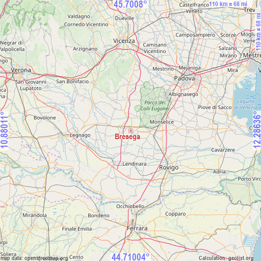
Bresega GPS coordinates[2]
45° 12' 27.288" North, 11° 34' 59.628" East
| Map corner | latitude | longitude |
|---|---|---|
| Upper-left | 45.7008°, | 10.88011° |
| Center: | 45.20758°, | 11.58323° |
| Lower-right: | 44.71004°, | 12.28636° |
| Map W x H: | 110.2×110.2 km | = 68.5×68.5mi |
| max Lat: | 47.04031° ⇑34.9% North |
| Bresega: | 45.20758° |
| min Lat: | ⇓65.1% South 35.50142° |
| min Long | Bresega | max Long |
| 6.69888° | 11.58323° | 18.48682° |
| W 50.4%⇐ | ⇒49.6% E |
Elevation
Elevation of Bresega is 8 m = 26 ft, and this is 298.7 m = 980 ft below average elevation for this country.
| Max E: |
2085 m = 6841 ft | 95.3% |
| Avg. | 306.7 m = 1006 ft | |
| Bresega | 8 m = 26 ft | |
Min E: |
-4 m = -13 ft | 4.7% |
See also: Italy elevation on elevation.city.
Geographical zone
Bresega is located in North temperate zone (between Tropic of Cancer and the Arctic Circle). Distance of this North polar circle is 2374.6 km =1475.5 mi to North.| Distance of | km | miles | from Bresega |
|---|---|---|---|
| North Pole | 4980.5 | 3094.7 | to North |
| Arctic Circle | 2374.6 | 1475.5 | to North |
| Tropic Cancer | 2420.7 | 1504.2 | to South |
| Equator | 5026.6 | 3123.4 | to South |


Nearby cities:
15 places around Bresega: (largest is in red/bold)
• Carceri
3.3 km =2.1 mi,  115°
115°
• Carmignano
8.1 km =5 mi,  140°
140°
• Casale di Scodosia
8.7 km =5.4 mi,  258°
258°
• Deserto
8.4 km =5.2 mi,  94°
94°
• Este
6.5 km =4 mi,  74°
74°
• Megliadino San Fidenzio
5.4 km =3.4 mi,  281°
281°
• Megliadino San Vitale
4.8 km =3 mi,  254°
254°
• Ospedaletto Euganeo
2 km =1.2 mi,  52°
52°
• Ponso
2.8 km =1.7 mi,  186°
186°
• Rivadolmo
6.6 km =4.1 mi, 46°
• Saletto
4.3 km =2.7 mi,  303°
303°
• San Fidenzio
5.2 km =3.2 mi, 280°
• Santa Margherita d'Adige
2.1 km =1.3 mi, 284°
• Vighizzolo d'Este
4.8 km =3 mi, 136°
• Villa Estense
7.7 km =4.8 mi, 118°
Sources, notices
• [Note1] Compared only with cities in Italy existing in our database
• [Src1] Map data: © OpenStreetMap contributors (CC-BY-SA)
• [Src2] Other city data from geonames.org with taken over terms of usage.
• [Src3] Geographical zone / Annual Mean Temperature by Robert A. Rohde @ Wikipedia
