Rivadolmo geodata
Rivadolmo (Veneto) is a populated place; located in Italy in Europe/Rome (GMT+2) time zone. With population of 590 people, there are 9093 cities with bigger population in this country. Compared to other cities in Italy, 66.1% of cities are located further ↓South; 51.1% of cities are located further ←West and 87.8% of cities have higher elevation than Rivadolmo. Note1


Rivadolmo GPS coordinates[2]
45° 14' 56.436" North, 11° 38' 39.768" East
| Map corner | latitude | longitude |
|---|---|---|
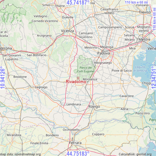
| Upper-left | 45.74187°, | 10.94126° |
| Center: | 45.24901°, | 11.64438° |
| Lower-right: | 44.75183°, | 12.34751° |
| Map W x H: | 110.1×110.1 km | = 68.4×68.4mi |
| max Lat: | 47.04031° ⇑33.9% North |
| Rivadolmo: | 45.24901° |
| min Lat: | ⇓66.1% South 35.50142° |
| min Long | Rivadolmo | max Long |
| 6.69888° | 11.64438° | 18.48682° |
| W 51.1%⇐ | ⇒48.9% E |
Elevation
Elevation of Rivadolmo is 23 m = 75 ft, and this is 283.7 m = 931 ft below average elevation for this country.
| Max E: |
2085 m = 6841 ft | 87.8% |
| Avg. | 306.7 m = 1006 ft | |
| Rivadolmo | 23 m = 75 ft | |
Min E: |
-4 m = -13 ft | 12.2% |
See also: Italy elevation on elevation.city.
Geographical zone
Rivadolmo is located in North temperate zone (between Tropic of Cancer and the Arctic Circle). Distance of this North polar circle is 2370 km =1472.6 mi to North.| Distance of | km | miles | from Rivadolmo |
|---|---|---|---|
| North Pole | 4975.8 | 3091.8 | to North |
| Arctic Circle | 2370 | 1472.6 | to North |
| Tropic Cancer | 2425.3 | 1507 | to South |
| Equator | 5031.2 | 3126.2 | to South |


Nearby cities:
15 places around Rivadolmo: (largest is in red/bold)
• Arquà Petrarca
6.4 km =4 mi,  69°
69°
• Baone
3.3 km =2.1 mi,  104°
104°
• Bresega
6.6 km =4.1 mi,  226°
226°
• Carceri
6.3 km =3.9 mi,  196°
196°
• Deserto
6.4 km =4 mi,  145°
145°
• Este
3.2 km =2 mi, 151°
• Fontanafredda
4.9 km =3 mi,  15°
15°
• Lozzo Atestino
5.9 km =3.7 mi,  328°
328°
• Monselice
8.3 km =5.2 mi, 97°
• Ospedaletto Euganeo
4.7 km =2.9 mi,  223°
223°
• Sant'Elena
8.6 km =5.3 mi,  142°
142°
• Santa Margherita d'Adige
7.9 km =4.9 mi,  238°
238°
• Valsanzibio
7.9 km =4.9 mi,  51°
51°
• Vighizzolo d'Este
8.2 km =5.1 mi,  190°
190°
• Villa Estense
8.5 km =5.3 mi,  166°
166°
Sources, notices
• [Note1] Compared only with cities in Italy existing in our database
• [Src1] Map data: © OpenStreetMap contributors (CC-BY-SA)
• [Src2] Other city data from geonames.org with taken over terms of usage.
• [Src3] Geographical zone / Annual Mean Temperature by Robert A. Rohde @ Wikipedia
