Bovezzo geodata
Bovezzo (Lombardy) is a seat of a third-order administrative division; located in Italy in Europe/Rome (GMT+2) time zone. With population of 7,469 people, there are 1303 cities with bigger population in this country. Compared to other cities in Italy, 76.6% of cities are located further ↓South; 65.6% of cities are located further →East and 56.5% of cities have higher elevation than Bovezzo. Note1


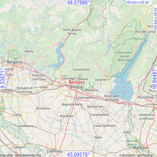
Bovezzo GPS coordinates[2]
45° 35' 23.928" North, 10° 14' 30.624" East
| Map corner | latitude | longitude |
|---|---|---|
| Upper-left | 46.07986°, | 9.53871° |
| Center: | 45.58998°, | 10.24184° |
| Lower-right: | 45.09578°, | 10.94497° |
| Map W x H: | 109.4×109.4 km | = 68×68mi |
| max Lat: | 47.04031° ⇑23.4% North |
| Bovezzo: | 45.58998° |
| min Lat: | ⇓76.6% South 35.50142° |
| min Long | Bovezzo | max Long |
| 6.69888° | 10.24184° | 18.48682° |
| W 34.4%⇐ | ⇒65.6% E |
Elevation
Elevation of Bovezzo is 191 m = 627 ft, and this is 115.7 m = 380 ft below average elevation for this country.
| Max E: |
2085 m = 6841 ft | 56.5% |
| Avg. | 306.7 m = 1006 ft | |
| Bovezzo | 191 m = 627 ft | |
Min E: |
-4 m = -13 ft | 43.5% |
See also: Italy elevation on elevation.city.
Geographical zone
Bovezzo is located in North temperate zone (between Tropic of Cancer and the Arctic Circle). Distance of this North polar circle is 2332 km =1449 mi to North.| Distance of | km | miles | from Bovezzo |
|---|---|---|---|
| North Pole | 4937.9 | 3068.3 | to North |
| Arctic Circle | 2332 | 1449 | to North |
| Tropic Cancer | 2463.2 | 1530.6 | to South |
| Equator | 5069.1 | 3149.8 | to South |


Nearby cities:
15 places around Bovezzo: (largest is in red/bold)
• Brescia
6.4 km =4 mi,  199°
199°
• Caino
6 km =3.7 mi,  68°
68°
• Cellatica
4.9 km =3 mi,  259°
259°
• Collebeato
2.7 km =1.7 mi,  248°
248°
• Concesio
2.6 km =1.6 mi,  311°
311°
• Fantasina
5.3 km =3.3 mi, 249°
• Gussago
6.6 km =4.1 mi, 263°
• Lumezzane
6.7 km =4.2 mi,  15°
15°
• Nave
3 km =1.9 mi,  101°
101°
• Piazza
6.7 km =4.2 mi,  267°
267°
• Ronco
8.3 km =5.2 mi, 274°
• San Gallo
6 km =3.7 mi,  120°
120°
• San Sebastiano
7 km =4.3 mi,  9°
9°
• San Vigilio
4.2 km =2.6 mi,  298°
298°
• Villa Carcina
6 km =3.7 mi,  323°
323°
Sources, notices
• [Note1] Compared only with cities in Italy existing in our database
• [Src1] Map data: © OpenStreetMap contributors (CC-BY-SA)
• [Src2] Other city data from geonames.org with taken over terms of usage.
• [Src3] Geographical zone / Annual Mean Temperature by Robert A. Rohde @ Wikipedia
