Concesio geodata
Concesio (Lombardy) is a seat of a third-order administrative division; located in Italy in Europe/Rome (GMT+2) time zone. With population of 11,262 people, there are 834 cities with bigger population in this country. Compared to other cities in Italy, 77.3% of cities are located further ↓South; 65.8% of cities are located further →East and 53.6% of cities have higher elevation than Concesio. Note1


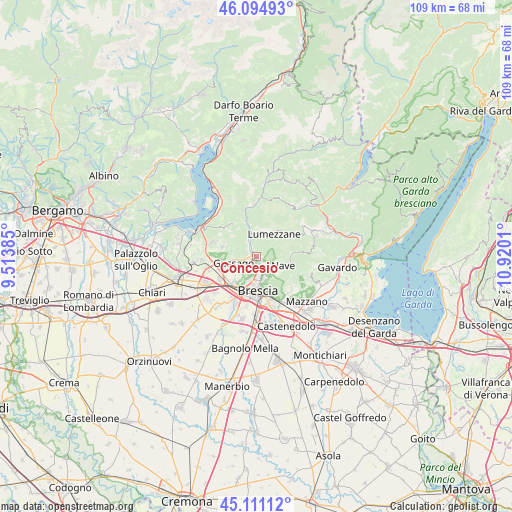
Concesio GPS coordinates[2]
45° 36' 18.648" North, 10° 13' 1.092" East
| Map corner | latitude | longitude |
|---|---|---|
| Upper-left | 46.09493°, | 9.51385° |
| Center: | 45.60518°, | 10.21697° |
| Lower-right: | 45.11112°, | 10.9201° |
| Map W x H: | 109.4×109.4 km | = 68×68mi |
| max Lat: | 47.04031° ⇑22.7% North |
| Concesio: | 45.60518° |
| min Lat: | ⇓77.3% South 35.50142° |
| min Long | Concesio | max Long |
| 6.69888° | 10.21697° | 18.48682° |
| W 34.2%⇐ | ⇒65.8% E |
Elevation
Elevation of Concesio is 213 m = 699 ft, and this is 93.7 m = 307 ft below average elevation for this country.
| Max E: |
2085 m = 6841 ft | 53.6% |
| Avg. | 306.7 m = 1006 ft | |
| Concesio | 213 m = 699 ft | |
Min E: |
-4 m = -13 ft | 46.4% |
See also: Italy elevation on elevation.city.
Geographical zone
Concesio is located in North temperate zone (between Tropic of Cancer and the Arctic Circle). Distance of this North polar circle is 2330.4 km =1448 mi to North.| Distance of | km | miles | from Concesio |
|---|---|---|---|
| North Pole | 4936.2 | 3067.2 | to North |
| Arctic Circle | 2330.4 | 1448 | to North |
| Tropic Cancer | 2464.9 | 1531.6 | to South |
| Equator | 5070.8 | 3150.8 | to South |


Nearby cities:
15 places around Concesio: (largest is in red/bold)
• Bovezzo
2.6 km =1.6 mi,  131°
131°
• Brione
6.7 km =4.2 mi,  307°
307°
• Cellatica
3.9 km =2.4 mi,  227°
227°
• Collebeato
2.7 km =1.7 mi,  191°
191°
• Fantasina
4.7 km =2.9 mi,  220°
220°
• Gussago
5.2 km =3.2 mi,  242°
242°
• Lumezzane
6 km =3.7 mi,  38°
38°
• Nave
5.4 km =3.4 mi,  114°
114°
• Piazza
5.2 km =3.2 mi,  247°
247°
• Ronco
6.4 km =4 mi,  260°
260°
• San Sebastiano
6.1 km =3.8 mi,  30°
30°
• San Vigilio
1.8 km =1.1 mi,  280°
280°
• San Zenone
6.8 km =4.2 mi, 306°
• Sarezzo
6.4 km =4 mi,  345°
345°
• Villa Carcina
3.5 km =2.2 mi,  331°
331°
Sources, notices
• [Note1] Compared only with cities in Italy existing in our database
• [Src1] Map data: © OpenStreetMap contributors (CC-BY-SA)
• [Src2] Other city data from geonames.org with taken over terms of usage.
• [Src3] Geographical zone / Annual Mean Temperature by Robert A. Rohde @ Wikipedia
