Boves geodata
Boves (Piedmont) is a seat of a third-order administrative division; located in Italy in Europe/Rome (GMT+2) time zone. With population of 7,089 people, there are 1379 cities with bigger population in this country. Compared to other cities in Italy, 51.5% of cities are located further ↑North; 97.5% of cities are located further →East and 83.7% of cities have lower elevation than Boves. Note1


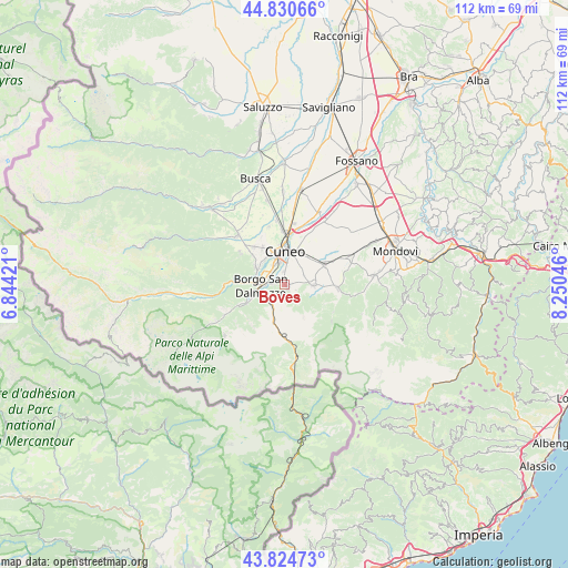
Boves GPS coordinates[2]
44° 19' 47.46" North, 7° 32' 50.388" East
| Map corner | latitude | longitude |
|---|---|---|
| Upper-left | 44.83066°, | 6.84421° |
| Center: | 44.32985°, | 7.54733° |
| Lower-right: | 43.82473°, | 8.25046° |
| Map W x H: | 111.8×111.8 km | = 69.5×69.5mi |
| max Lat: | 47.04031° ⇑51.5% North |
| Boves: | 44.32985° |
| min Lat: | ⇓48.5% South 35.50142° |
| min Long | Boves | max Long |
| 6.69888° | 7.54733° | 18.48682° |
| W 2.5%⇐ | ⇒97.5% E |
Elevation
Elevation of Boves is 587 m = 1926 ft, and this is 280.3 m = 920 ft above average elevation for this country.
| Max E: |
2085 m = 6841 ft | 16.3% |
| Boves | 587 m 1926 ft | |
| Avg. | 306.7 m = 1006 ft | |
Min E: |
-4 m = -13 ft | 83.7% |
See also: Italy elevation on elevation.city.
Geographical zone
Boves is located in North temperate zone (between Tropic of Cancer and the Arctic Circle). Distance of this Northern Tropic circle is 2323.1 km =1443.5 mi to South.| Distance of | km | miles | from Boves |
|---|---|---|---|
| North Pole | 5078 | 3155.3 | to North |
| Arctic Circle | 2472.2 | 1536.2 | to North |
| Tropic Cancer | 2323.1 | 1443.5 | to South |
| Equator | 4929 | 3062.7 | to South |


Nearby cities:
15 places around Boves: (largest is in red/bold)
• Beinette
8.6 km =5.3 mi,  63°
63°
• Borgo San Dalmazzo
4.4 km =2.7 mi,  281°
281°
• Cervasca
8.3 km =5.2 mi,  313°
313°
• Cuneo
6.8 km =4.2 mi,  0°
0°
• Peveragno
5.8 km =3.6 mi,  100°
100°
• Rivoira
2.2 km =1.4 mi,  119°
119°
• Roaschia
9.9 km =6.2 mi,  227°
227°
• Robilante
4.9 km =3 mi,  213°
213°
• Roccasparvera
8.5 km =5.3 mi, 279°
• Roccavione
5.8 km =3.6 mi,  251°
251°
• San Defendente
8.1 km =5 mi,  326°
326°
• San Lorenzo
4.2 km =2.6 mi, 58°
• San Rocco
9.5 km =5.9 mi,  321°
321°
• Vernante
9.5 km =5.9 mi,  186°
186°
• Vignolo
7.1 km =4.4 mi,  302°
302°
Sources, notices
• [Note1] Compared only with cities in Italy existing in our database
• [Src1] Map data: © OpenStreetMap contributors (CC-BY-SA)
• [Src2] Other city data from geonames.org with taken over terms of usage.
• [Src3] Geographical zone / Annual Mean Temperature by Robert A. Rohde @ Wikipedia
