Cuneo geodata
Cuneo (Piedmont) is a seat of a second-order administrative division; located in Italy in Europe/Rome (GMT+2) time zone. With population of 46,416 people, there are 137 cities with bigger population in this country. Compared to other cities in Italy, 50.6% of cities are located further ↑North; 97.5% of cities are located further →East and 81.5% of cities have lower elevation than Cuneo. Note1


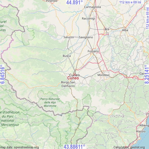
Cuneo GPS coordinates[2]
44° 23' 26.556" North, 7° 32' 53.808" East
| Map corner | latitude | longitude |
|---|---|---|
| Upper-left | 44.891°, | 6.84516° |
| Center: | 44.39071°, | 7.54828° |
| Lower-right: | 43.88611°, | 8.25141° |
| Map W x H: | 111.7×111.7 km | = 69.4×69.4mi |
| max Lat: | 47.04031° ⇑50.6% North |
| Cuneo: | 44.39071° |
| min Lat: | ⇓49.4% South 35.50142° |
| min Long | Cuneo | max Long |
| 6.69888° | 7.54828° | 18.48682° |
| W 2.5%⇐ | ⇒97.5% E |
Elevation
Elevation of Cuneo is 546 m = 1791 ft, and this is 239.3 m = 785 ft above average elevation for this country.
| Max E: |
2085 m = 6841 ft | 18.5% |
| Cuneo | 546 m 1791 ft | |
| Avg. | 306.7 m = 1006 ft | |
Min E: |
-4 m = -13 ft | 81.5% |
See also: Cuneo elevation on elevation.city.
Geographical zone
Cuneo is located in North temperate zone (between Tropic of Cancer and the Arctic Circle). Distance of this Northern Tropic circle is 2329.9 km =1447.7 mi to South.| Distance of | km | miles | from Cuneo |
|---|---|---|---|
| North Pole | 5071.3 | 3151.2 | to North |
| Arctic Circle | 2465.4 | 1531.9 | to North |
| Tropic Cancer | 2329.9 | 1447.7 | to South |
| Equator | 4935.8 | 3067 | to South |


Nearby cities:
15 places around Cuneo: (largest is in red/bold)
• Beinette
8.2 km =5.1 mi,  111°
111°
• Bernezzo
8.9 km =5.5 mi,  266°
266°
• Borgo San Dalmazzo
7.3 km =4.5 mi,  216°
216°
• Boves
6.8 km =4.2 mi,  180°
180°
• Castelletto Stura
9.3 km =5.8 mi,  50°
50°
• Cervasca
6.2 km =3.9 mi,  259°
259°
• Passatore
5.6 km =3.5 mi,  324°
324°
• Peveragno
9.6 km =6 mi,  144°
144°
• Rivoira
8.1 km =5 mi,  166°
166°
• Roata Chiusani
8.6 km =5.3 mi,  24°
24°
• Roata Rossi
6.2 km =3.9 mi,  343°
343°
• San Defendente
4.6 km =2.9 mi, 270°
• San Lorenzo
5.8 km =3.6 mi, 142°
• San Rocco
6.1 km =3.8 mi,  276°
276°
• Vignolo
6.8 km =4.2 mi,  243°
243°
Sources, notices
• [Note1] Compared only with cities in Italy existing in our database
• [Src1] Map data: © OpenStreetMap contributors (CC-BY-SA)
• [Src2] Other city data from geonames.org with taken over terms of usage.
• [Src3] Geographical zone / Annual Mean Temperature by Robert A. Rohde @ Wikipedia
