Bormio geodata
Bormio (Lombardy) is a seat of a third-order administrative division; located in Italy in Europe/Rome (GMT+2) time zone. With population of 3,894 people, there are 2459 cities with bigger population in this country. Compared to other cities in Italy, 98.2% of cities are located further ↓South; 64.2% of cities are located further →East and 98.6% of cities have lower elevation than Bormio. Note1


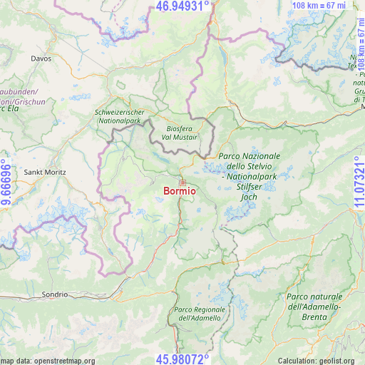
Bormio GPS coordinates[2]
46° 28' 1.812" North, 10° 22' 12.288" East
| Map corner | latitude | longitude |
|---|---|---|
| Upper-left | 46.94931°, | 9.66696° |
| Center: | 46.46717°, | 10.37008° |
| Lower-right: | 45.98072°, | 11.07321° |
| Map W x H: | 107.7×107.7 km | = 66.9×66.9mi |
| max Lat: | 47.04031° ⇑1.8% North |
| Bormio: | 46.46717° |
| min Lat: | ⇓98.2% South 35.50142° |
| min Long | Bormio | max Long |
| 6.69888° | 10.37008° | 18.48682° |
| W 35.8%⇐ | ⇒64.2% E |
Elevation
Elevation of Bormio is 1204 m = 3950 ft, and this is 897.3 m = 2944 ft above average elevation for this country.
| Max E: |
2085 m = 6841 ft | 1.4% |
| Bormio | 1204 m 3950 ft | |
| Avg. | 306.7 m = 1006 ft | |
Min E: |
-4 m = -13 ft | 98.6% |
See also: Italy elevation on elevation.city.
Geographical zone
Bormio is located in North temperate zone (between Tropic of Cancer and the Arctic Circle). Distance of this North polar circle is 2234.5 km =1388.5 mi to North.| Distance of | km | miles | from Bormio |
|---|---|---|---|
| North Pole | 4840.4 | 3007.7 | to North |
| Arctic Circle | 2234.5 | 1388.5 | to North |
| Tropic Cancer | 2560.7 | 1591.1 | to South |
| Equator | 5166.7 | 3210.4 | to South |


Nearby cities:
15 places around Bormio: (largest is in red/bold)
• Cepina
3.6 km =2.2 mi,  196°
196°
• Grosio
20 km =12.4 mi, 201°
• Grosotto
22.3 km =13.9 mi, 202°
• Isolaccia
6.3 km =3.9 mi,  292°
292°
• Livigno
19.7 km =12.2 mi, 293°
• Pradelle
4.8 km =3 mi,  295°
295°
• San Nicolò
3.1 km =1.9 mi,  98°
98°
• Sant'Anna
16.3 km =10.1 mi, 294°
• Sant'Antonio
3.7 km =2.3 mi, 100°
• Santa Maria
20.3 km =12.6 mi, 296°
• Semogo
7.9 km =4.9 mi,  284°
284°
• Sondalo
15.6 km =9.7 mi,  192°
192°
• Stelvio
19.8 km =12.3 mi,  42°
42°
• Tubre
20.9 km =13 mi,  19°
19°
• Valdisotto
3.8 km =2.4 mi, 195°
Sources, notices
• [Note1] Compared only with cities in Italy existing in our database
• [Src1] Map data: © OpenStreetMap contributors (CC-BY-SA)
• [Src2] Other city data from geonames.org with taken over terms of usage.
• [Src3] Geographical zone / Annual Mean Temperature by Robert A. Rohde @ Wikipedia
