Stelvio geodata
Stelvio (Trentino-Alto Adige) is a seat of a third-order administrative division; located in Italy in Europe/Rome (GMT+2) time zone. With population of 444 people, there are 10115 cities with bigger population in this country. Compared to other cities in Italy, 98.9% of cities are located further ↓South; 62.3% of cities are located further →East and 99.1% of cities have lower elevation than Stelvio. Note1


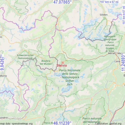
Stelvio GPS coordinates[2]
46° 35' 51.612" North, 10° 32' 44.88" East
| Map corner | latitude | longitude |
|---|---|---|
| Upper-left | 47.07865°, | 9.84267° |
| Center: | 46.59767°, | 10.5458° |
| Lower-right: | 46.11239°, | 11.24893° |
| Map W x H: | 107.4×107.4 km | = 66.7×66.7mi |
| max Lat: | 47.04031° ⇑1.1% North |
| Stelvio: | 46.59767° |
| min Lat: | ⇓98.9% South 35.50142° |
| min Long | Stelvio | max Long |
| 6.69888° | 10.5458° | 18.48682° |
| W 37.7%⇐ | ⇒62.3% E |
Elevation
Elevation of Stelvio is 1291 m = 4236 ft, and this is 984.3 m = 3229 ft above average elevation for this country.
| Max E: |
2085 m = 6841 ft | 0.90000000000001% |
| Stelvio | 1291 m 4236 ft | |
| Avg. | 306.7 m = 1006 ft | |
Min E: |
-4 m = -13 ft | 99.1% |
See also: Italy elevation on elevation.city.
Geographical zone
Stelvio is located in North temperate zone (between Tropic of Cancer and the Arctic Circle). Distance of this North polar circle is 2220 km =1379.4 mi to North.| Distance of | km | miles | from Stelvio |
|---|---|---|---|
| North Pole | 4825.9 | 2998.7 | to North |
| Arctic Circle | 2220 | 1379.4 | to North |
| Tropic Cancer | 2575.3 | 1600.2 | to South |
| Equator | 5181.2 | 3219.4 | to South |


Nearby cities:
15 places around Stelvio: (largest is in red/bold)
• Burgusio
12.6 km =7.8 mi,  354°
354°
• Ganda
18.6 km =11.6 mi,  104°
104°
• Glorenza
8.2 km =5.1 mi,  5°
5°
• Lasa
11.8 km =7.3 mi,  79°
79°
• Laudes
9.1 km =5.7 mi, 353°
• Malles Venosta
10 km =6.2 mi,  0°
0°
• Meiern
18.5 km =11.5 mi, 101°
• Oris
8.5 km =5.3 mi,  65°
65°
• Prato Allo Stelvio
4.2 km =2.6 mi,  55°
55°
• San Nicolò
18.2 km =11.3 mi,  214°
214°
• San Valentino alla Muta
18.5 km =11.5 mi,  357°
357°
• Sant'Antonio
18.1 km =11.2 mi, 212°
• Silandro
17.3 km =10.7 mi, 78°
• Sluderno
8 km =5 mi,  20°
20°
• Tubre
8.1 km =5 mi,  309°
309°
Sources, notices
• [Note1] Compared only with cities in Italy existing in our database
• [Src1] Map data: © OpenStreetMap contributors (CC-BY-SA)
• [Src2] Other city data from geonames.org with taken over terms of usage.
• [Src3] Geographical zone / Annual Mean Temperature by Robert A. Rohde @ Wikipedia
