Bordolano geodata
Bordolano (Lombardy) is a seat of a third-order administrative division; located in Italy in Europe/Rome (GMT+2) time zone. With population of 621 people, there are 8833 cities with bigger population in this country. Compared to other cities in Italy, 67.2% of cities are located further ↓South; 68% of cities are located further →East and 77.5% of cities have higher elevation than Bordolano. Note1


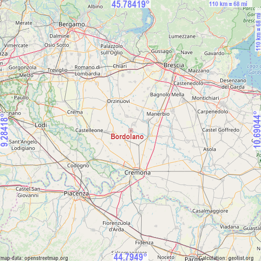
Bordolano GPS coordinates[2]
45° 17' 30.12" North, 9° 59' 14.316" East
| Map corner | latitude | longitude |
|---|---|---|
| Upper-left | 45.78419°, | 9.28418° |
| Center: | 45.2917°, | 9.98731° |
| Lower-right: | 44.7949°, | 10.69044° |
| Map W x H: | 110×110 km | = 68.4×68.4mi |
| max Lat: | 47.04031° ⇑32.8% North |
| Bordolano: | 45.2917° |
| min Lat: | ⇓67.2% South 35.50142° |
| min Long | Bordolano | max Long |
| 6.69888° | 9.98731° | 18.48682° |
| W 32%⇐ | ⇒68% E |
Elevation
Elevation of Bordolano is 62 m = 203 ft, and this is 244.7 m = 803 ft below average elevation for this country.
| Max E: |
2085 m = 6841 ft | 77.5% |
| Avg. | 306.7 m = 1006 ft | |
| Bordolano | 62 m = 203 ft | |
Min E: |
-4 m = -13 ft | 22.5% |
See also: Italy elevation on elevation.city.
Geographical zone
Bordolano is located in North temperate zone (between Tropic of Cancer and the Arctic Circle). Distance of this North polar circle is 2365.2 km =1469.7 mi to North.| Distance of | km | miles | from Bordolano |
|---|---|---|---|
| North Pole | 4971.1 | 3088.9 | to North |
| Arctic Circle | 2365.2 | 1469.7 | to North |
| Tropic Cancer | 2430 | 1509.9 | to South |
| Equator | 5036 | 3129.2 | to South |


Nearby cities:
15 places around Bordolano: (largest is in red/bold)
• Azzanello
5.8 km =3.6 mi,  294°
294°
• Borgo San Giacomo
6.4 km =4 mi,  346°
346°
• Casalbuttano
4.9 km =3 mi,  204°
204°
• Casalmorano
7 km =4.3 mi,  266°
266°
• Castelvisconti
3.9 km =2.4 mi, 292°
• Cignone
2.5 km =1.6 mi,  184°
184°
• Corte de' Cortesi
2.6 km =1.6 mi,  143°
143°
• Corte de' Cortesi con Cignone
2.6 km =1.6 mi, 142°
• Motella
6.2 km =3.9 mi,  16°
16°
• Olmeneta
6.9 km =4.3 mi,  155°
155°
• Paderno Ponchielli
7.5 km =4.7 mi,  217°
217°
• Quinzano d'Oglio
3 km =1.9 mi,  32°
32°
• Robecco d'Oglio
7.9 km =4.9 mi,  117°
117°
• Verolanuova
8.2 km =5.1 mi,  60°
60°
• Verolavecchia
6.7 km =4.2 mi,  52°
52°
Sources, notices
• [Note1] Compared only with cities in Italy existing in our database
• [Src1] Map data: © OpenStreetMap contributors (CC-BY-SA)
• [Src2] Other city data from geonames.org with taken over terms of usage.
• [Src3] Geographical zone / Annual Mean Temperature by Robert A. Rohde @ Wikipedia
