Besnate geodata
Besnate (Lombardy) is a seat of a third-order administrative division; located in Italy in Europe/Rome (GMT+2) time zone. With population of 5,272 people, there are 1850 cities with bigger population in this country. Compared to other cities in Italy, 81.1% of cities are located further ↓South; 84.6% of cities are located further →East and 59.5% of cities have lower elevation than Besnate. Note1


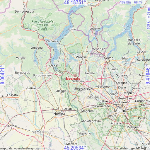
Besnate GPS coordinates[2]
45° 41' 54.888" North, 8° 46' 2.424" East
| Map corner | latitude | longitude |
|---|---|---|
| Upper-left | 46.18751°, | 8.06421° |
| Center: | 45.69858°, | 8.76734° |
| Lower-right: | 45.20534°, | 9.47046° |
| Map W x H: | 109.2×109.2 km | = 67.9×67.9mi |
| max Lat: | 47.04031° ⇑18.9% North |
| Besnate: | 45.69858° |
| min Lat: | ⇓81.1% South 35.50142° |
| min Long | Besnate | max Long |
| 6.69888° | 8.76734° | 18.48682° |
| W 15.4%⇐ | ⇒84.6% E |
Elevation
Elevation of Besnate is 296 m = 971 ft, and this is 10.7 m = 35 ft below average elevation for this country.
| Max E: |
2085 m = 6841 ft | 40.5% |
| Avg. | 306.7 m = 1006 ft | |
| Besnate | 296 m = 971 ft | |
Min E: |
-4 m = -13 ft | 59.5% |
See also: Italy elevation on elevation.city.
Geographical zone
Besnate is located in North temperate zone (between Tropic of Cancer and the Arctic Circle). Distance of this North polar circle is 2320 km =1441.6 mi to North.| Distance of | km | miles | from Besnate |
|---|---|---|---|
| North Pole | 4925.9 | 3060.8 | to North |
| Arctic Circle | 2320 | 1441.6 | to North |
| Tropic Cancer | 2475.3 | 1538.1 | to South |
| Equator | 5081.2 | 3157.3 | to South |


Nearby cities:
15 places around Besnate: (largest is in red/bold)
• Albizzate
4.2 km =2.6 mi,  41°
41°
• Arsago Seprio
2.8 km =1.7 mi,  244°
244°
• Casorate Sempione
3.5 km =2.2 mi,  209°
209°
• Cassano Magnago
5.5 km =3.4 mi,  122°
122°
• Cavaria Con Premezzo
2.9 km =1.8 mi,  103°
103°
• Crugnola
3.8 km =2.4 mi,  333°
333°
• Gallarate
4.7 km =2.9 mi,  156°
156°
• Jerago Con Orago
2.3 km =1.4 mi,  73°
73°
• Monte
4.6 km =2.9 mi, 66°
• Montonate
5.4 km =3.4 mi,  4°
4°
• Mornago
5.3 km =3.3 mi,  345°
345°
• Oggiona-Santo Stefano
3.9 km =2.4 mi,  80°
80°
• Solbiate Arno
4.3 km =2.7 mi,  57°
57°
• Somma Lombardo
5 km =3.1 mi,  248°
248°
• Sumirago
4.4 km =2.7 mi,  16°
16°
Sources, notices
• [Note1] Compared only with cities in Italy existing in our database
• [Src1] Map data: © OpenStreetMap contributors (CC-BY-SA)
• [Src2] Other city data from geonames.org with taken over terms of usage.
• [Src3] Geographical zone / Annual Mean Temperature by Robert A. Rohde @ Wikipedia
