Balzola geodata
Balzola (Piedmont) is a seat of a third-order administrative division; located in Italy in Europe/Rome (GMT+2) time zone. With population of 1,363 people, there are 5462 cities with bigger population in this country. Compared to other cities in Italy, 64.5% of cities are located further ↓South; 89.1% of cities are located further →East and 66% of cities have higher elevation than Balzola. Note1


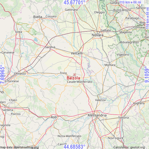
Balzola GPS coordinates[2]
45° 11' 0.888" North, 8° 24' 9.972" East
| Map corner | latitude | longitude |
|---|---|---|
| Upper-left | 45.67701°, | 7.69965° |
| Center: | 45.18358°, | 8.40277° |
| Lower-right: | 44.68583°, | 9.1059° |
| Map W x H: | 110.2×110.2 km | = 68.5×68.5mi |
| max Lat: | 47.04031° ⇑35.5% North |
| Balzola: | 45.18358° |
| min Lat: | ⇓64.5% South 35.50142° |
| min Long | Balzola | max Long |
| 6.69888° | 8.40277° | 18.48682° |
| W 10.9%⇐ | ⇒89.1% E |
Elevation
Elevation of Balzola is 121 m = 397 ft, and this is 185.7 m = 609 ft below average elevation for this country.
| Max E: |
2085 m = 6841 ft | 66% |
| Avg. | 306.7 m = 1006 ft | |
| Balzola | 121 m = 397 ft | |
Min E: |
-4 m = -13 ft | 34% |
See also: Italy elevation on elevation.city.
Geographical zone
Balzola is located in North temperate zone (between Tropic of Cancer and the Arctic Circle). Distance of this North polar circle is 2377.2 km =1477.1 mi to North.| Distance of | km | miles | from Balzola |
|---|---|---|---|
| North Pole | 4983.1 | 3096.4 | to North |
| Arctic Circle | 2377.2 | 1477.1 | to North |
| Tropic Cancer | 2418 | 1502.5 | to South |
| Equator | 5023.9 | 3121.7 | to South |


Nearby cities:
15 places around Balzola: (largest is in red/bold)
• Asigliano Vercellese
8.7 km =5.4 mi,  2°
2°
• Caresana
9 km =5.6 mi,  62°
62°
• Casale Monferrato
6.8 km =4.2 mi,  145°
145°
• Coniolo Bricco
4.7 km =2.9 mi,  212°
212°
• Costanzana
6.5 km =4 mi,  336°
336°
• Morano sul Po
3.4 km =2.1 mi,  235°
235°
• Pertengo
5.9 km =3.7 mi,  10°
10°
• Pontestura
7.1 km =4.4 mi,  230°
230°
• Rive
3.5 km =2.2 mi,  18°
18°
• San Giorgio
8.5 km =5.3 mi,  173°
173°
• San Giorgio Monferrato
8.5 km =5.3 mi, 172°
• Stroppiana
6.6 km =4.1 mi,  37°
37°
• Tricerro
8.3 km =5.2 mi,  314°
314°
• Trino
8.5 km =5.3 mi,  278°
278°
• Villanova Monferrato
5.9 km =3.7 mi,  92°
92°
Sources, notices
• [Note1] Compared only with cities in Italy existing in our database
• [Src1] Map data: © OpenStreetMap contributors (CC-BY-SA)
• [Src2] Other city data from geonames.org with taken over terms of usage.
• [Src3] Geographical zone / Annual Mean Temperature by Robert A. Rohde @ Wikipedia
