Pertengo geodata
Pertengo (Piedmont) is a seat of a third-order administrative division; located in Italy in Europe/Rome (GMT+2) time zone. With population of 305 people, there are 10655 cities with bigger population in this country. Compared to other cities in Italy, 65.8% of cities are located further ↓South; 88.9% of cities are located further →East and 65.3% of cities have higher elevation than Pertengo. Note1


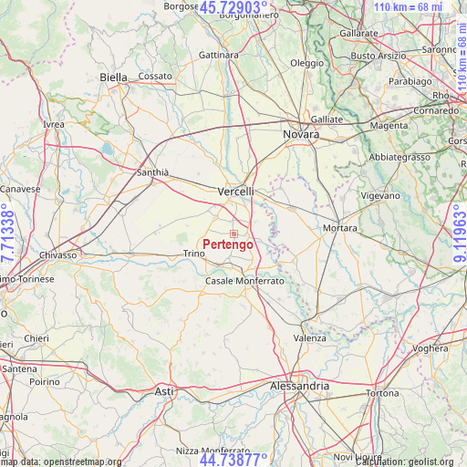
Pertengo GPS coordinates[2]
45° 14' 9.816" North, 8° 24' 59.436" East
| Map corner | latitude | longitude |
|---|---|---|
| Upper-left | 45.72903°, | 7.71338° |
| Center: | 45.23606°, | 8.41651° |
| Lower-right: | 44.73877°, | 9.11963° |
| Map W x H: | 110.1×110.1 km | = 68.4×68.4mi |
| max Lat: | 47.04031° ⇑34.2% North |
| Pertengo: | 45.23606° |
| min Lat: | ⇓65.8% South 35.50142° |
| min Long | Pertengo | max Long |
| 6.69888° | 8.41651° | 18.48682° |
| W 11.1%⇐ | ⇒88.9% E |
Elevation
Elevation of Pertengo is 126 m = 413 ft, and this is 180.7 m = 593 ft below average elevation for this country.
| Max E: |
2085 m = 6841 ft | 65.3% |
| Avg. | 306.7 m = 1006 ft | |
| Pertengo | 126 m = 413 ft | |
Min E: |
-4 m = -13 ft | 34.7% |
See also: Italy elevation on elevation.city.
Geographical zone
Pertengo is located in North temperate zone (between Tropic of Cancer and the Arctic Circle). Distance of this North polar circle is 2371.4 km =1473.5 mi to North.| Distance of | km | miles | from Pertengo |
|---|---|---|---|
| North Pole | 4977.3 | 3092.7 | to North |
| Arctic Circle | 2371.4 | 1473.5 | to North |
| Tropic Cancer | 2423.9 | 1506.1 | to South |
| Equator | 5029.8 | 3125.4 | to South |


Nearby cities:
15 places around Pertengo: (largest is in red/bold)
• Asigliano Vercellese
2.9 km =1.8 mi,  347°
347°
• Balzola
5.9 km =3.7 mi,  190°
190°
• Caresana
7.1 km =4.4 mi,  103°
103°
• Costanzana
3.7 km =2.3 mi,  272°
272°
• Desana
5.9 km =3.7 mi,  308°
308°
• Lignana
7.9 km =4.9 mi, 314°
• Morano sul Po
8.7 km =5.4 mi,  206°
206°
• Motta Dè Conti
9.4 km =5.8 mi,  120°
120°
• Pezzana
6 km =3.7 mi,  61°
61°
• Prarolo
7 km =4.3 mi,  43°
43°
• Rive
2.5 km =1.6 mi,  179°
179°
• Stroppiana
3 km =1.9 mi, 101°
• Tricerro
7 km =4.3 mi, 269°
• Vercelli
9.5 km =5.9 mi,  1°
1°
• Villanova Monferrato
7.8 km =4.8 mi,  141°
141°
Sources, notices
• [Note1] Compared only with cities in Italy existing in our database
• [Src1] Map data: © OpenStreetMap contributors (CC-BY-SA)
• [Src2] Other city data from geonames.org with taken over terms of usage.
• [Src3] Geographical zone / Annual Mean Temperature by Robert A. Rohde @ Wikipedia
