Arcugnano-Torri geodata
Arcugnano-Torri (Veneto) is a seat of a third-order administrative division; located in Italy in Europe/Rome (GMT+2) time zone. With population of 2,499 people, there are 3521 cities with bigger population in this country. Compared to other cities in Italy, 73.5% of cities are located further ↓South; 50% of cities are located further ←West and 82.9% of cities have higher elevation than Arcugnano-Torri. Note1


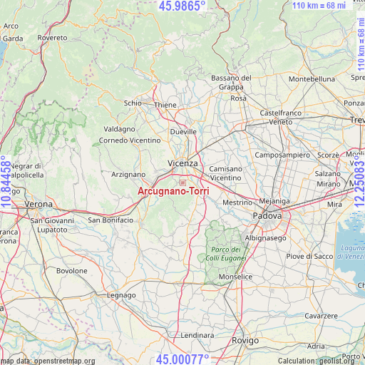
Arcugnano-Torri GPS coordinates[2]
45° 29' 44.844" North, 11° 32' 51.72" East
| Map corner | latitude | longitude |
|---|---|---|
| Upper-left | 45.9865°, | 10.84458° |
| Center: | 45.49579°, | 11.5477° |
| Lower-right: | 45.00077°, | 12.25083° |
| Map W x H: | 109.6×109.6 km | = 68.1×68.1mi |
| max Lat: | 47.04031° ⇑26.5% North |
| Arcugnano-Torri: | 45.49579° |
| min Lat: | ⇓73.5% South 35.50142° |
| min Long | Arcugnano-Torri | max Long |
| 6.69888° | 11.5477° | 18.48682° |
| W 50%⇐ | ⇒50% E |
Elevation
Elevation of Arcugnano-Torri is 38 m = 125 ft, and this is 268.7 m = 882 ft below average elevation for this country.
| Max E: |
2085 m = 6841 ft | 82.9% |
| Avg. | 306.7 m = 1006 ft | |
| Arcugnano-Torri | 38 m = 125 ft | |
Min E: |
-4 m = -13 ft | 17.1% |
See also: Italy elevation on elevation.city.
Geographical zone
Arcugnano-Torri is located in North temperate zone (between Tropic of Cancer and the Arctic Circle). Distance of this North polar circle is 2342.5 km =1455.6 mi to North.| Distance of | km | miles | from Arcugnano-Torri |
|---|---|---|---|
| North Pole | 4948.4 | 3074.8 | to North |
| Arctic Circle | 2342.5 | 1455.6 | to North |
| Tropic Cancer | 2452.7 | 1524 | to South |
| Equator | 5058.7 | 3143.3 | to South |


Nearby cities:
15 places around Arcugnano-Torri: (largest is in red/bold)
• Altavilla Vicentina
6.5 km =4 mi,  287°
287°
• Castegnero
6.6 km =4.1 mi,  154°
154°
• Creazzo
6.7 km =4.2 mi,  306°
306°
• Longare
5.1 km =3.2 mi,  114°
114°
• Lumignano
5.1 km =3.2 mi,  142°
142°
• Marola
7.8 km =4.8 mi,  51°
51°
• Nogarazza
3.2 km =2 mi,  295°
295°
• Pianezze del Lago
2.1 km =1.3 mi, 148°
• Ponte di Castegnero
7.8 km =4.8 mi, 147°
• Secula
5.7 km =3.5 mi, 106°
• Tavernelle
8 km =5 mi, 285°
• Tormeno
1 km =0.6 mi,  19°
19°
• Torri di Quartesolo
6.5 km =4 mi,  66°
66°
• Vicenza
5.7 km =3.5 mi,  359°
359°
• Villaggio Montegrappa
7.7 km =4.8 mi,  42°
42°
Sources, notices
• [Note1] Compared only with cities in Italy existing in our database
• [Src1] Map data: © OpenStreetMap contributors (CC-BY-SA)
• [Src2] Other city data from geonames.org with taken over terms of usage.
• [Src3] Geographical zone / Annual Mean Temperature by Robert A. Rohde @ Wikipedia
