Arce geodata
Arce (Latium) is a seat of a third-order administrative division; located in Italy in Europe/Rome (GMT+2) time zone. With population of 2,154 people, there are 3926 cities with bigger population in this country. Compared to other cities in Italy, 74.1% of cities are located further ↑North; 74.5% of cities are located further ←West and 56.8% of cities have higher elevation than Arce. Note1


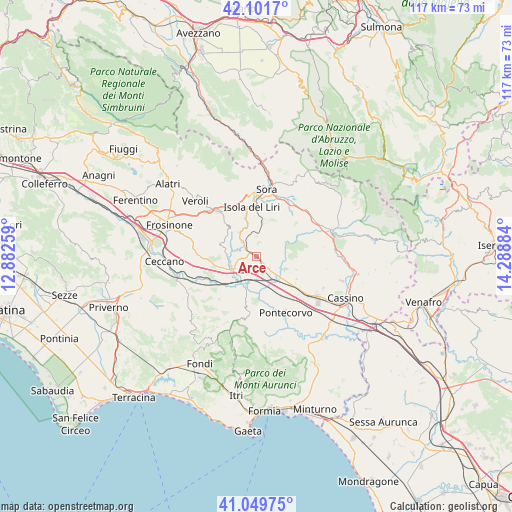
Arce GPS coordinates[2]
41° 34' 40.332" North, 13° 35' 8.556" East
| Map corner | latitude | longitude |
|---|---|---|
| Upper-left | 42.1017°, | 12.88259° |
| Center: | 41.57787°, | 13.58571° |
| Lower-right: | 41.04975°, | 14.28884° |
| Map W x H: | 117×117 km | = 72.7×72.7mi |
| max Lat: | 47.04031° ⇑74.1% North |
| Arce: | 41.57787° |
| min Lat: | ⇓25.9% South 35.50142° |
| min Long | Arce | max Long |
| 6.69888° | 13.58571° | 18.48682° |
| W 74.5%⇐ | ⇒25.5% E |
Elevation
Elevation of Arce is 189 m = 620 ft, and this is 117.7 m = 386 ft below average elevation for this country.
| Max E: |
2085 m = 6841 ft | 56.8% |
| Avg. | 306.7 m = 1006 ft | |
| Arce | 189 m = 620 ft | |
Min E: |
-4 m = -13 ft | 43.2% |
See also: Italy elevation on elevation.city.
Geographical zone
Arce is located in North temperate zone (between Tropic of Cancer and the Arctic Circle). Distance of this Northern Tropic circle is 2017.1 km =1253.4 mi to South.| Distance of | km | miles | from Arce |
|---|---|---|---|
| North Pole | 5384 | 3345.5 | to North |
| Arctic Circle | 2778.1 | 1726.2 | to North |
| Tropic Cancer | 2017.1 | 1253.4 | to South |
| Equator | 4623 | 2872.6 | to South |


Nearby cities:
15 places around Arce: (largest is in red/bold)
• Anitrella-Chiaiamari
7.4 km =4.6 mi,  335°
335°
• Arpino
8 km =5 mi,  15°
15°
• Ceprano
6.9 km =4.3 mi,  238°
238°
• Coldragone
3 km =1.9 mi,  149°
149°
• Collefontana-Fontana Liri Inferiore
4.8 km =3 mi,  321°
321°
• Colli
5.3 km =3.3 mi,  304°
304°
• Girate
7.5 km =4.7 mi,  328°
328°
• La Lucca
8.2 km =5.1 mi,  307°
307°
• Rocca d'Arce
1 km =0.6 mi,  357°
357°
• Roccasecca
7.4 km =4.6 mi,  113°
113°
• Roccasecca Stazione
7.3 km =4.5 mi,  132°
132°
• San Giovanni Incarico
8.9 km =5.5 mi,  194°
194°
• Santopadre
4.9 km =3 mi,  57°
57°
• Strangolagalli
8.1 km =5 mi,  287°
287°
• Villa Felice
3.7 km =2.3 mi, 133°
Sources, notices
• [Note1] Compared only with cities in Italy existing in our database
• [Src1] Map data: © OpenStreetMap contributors (CC-BY-SA)
• [Src2] Other city data from geonames.org with taken over terms of usage.
• [Src3] Geographical zone / Annual Mean Temperature by Robert A. Rohde @ Wikipedia
