Ceprano geodata
Ceprano (Latium) is a seat of a third-order administrative division; located in Italy in Europe/Rome (GMT+2) time zone. With population of 5,740 people, there are 1714 cities with bigger population in this country. Compared to other cities in Italy, 74.4% of cities are located further ↑North; 73.8% of cities are located further ←West and 67.6% of cities have higher elevation than Ceprano. Note1


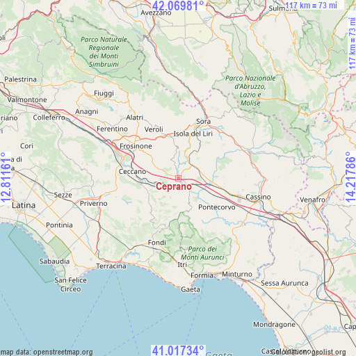
Ceprano GPS coordinates[2]
41° 32' 44.592" North, 13° 30' 53.028" East
| Map corner | latitude | longitude |
|---|---|---|
| Upper-left | 42.06981°, | 12.81161° |
| Center: | 41.54572°, | 13.51473° |
| Lower-right: | 41.01734°, | 14.21786° |
| Map W x H: | 117×117 km | = 72.7×72.7mi |
| max Lat: | 47.04031° ⇑74.4% North |
| Ceprano: | 41.54572° |
| min Lat: | ⇓25.6% South 35.50142° |
| min Long | Ceprano | max Long |
| 6.69888° | 13.51473° | 18.48682° |
| W 73.8%⇐ | ⇒26.2% E |
Elevation
Elevation of Ceprano is 111 m = 364 ft, and this is 195.7 m = 642 ft below average elevation for this country.
| Max E: |
2085 m = 6841 ft | 67.6% |
| Avg. | 306.7 m = 1006 ft | |
| Ceprano | 111 m = 364 ft | |
Min E: |
-4 m = -13 ft | 32.4% |
See also: Italy elevation on elevation.city.
Geographical zone
Ceprano is located in North temperate zone (between Tropic of Cancer and the Arctic Circle). Distance of this Northern Tropic circle is 2013.5 km =1251.1 mi to South.| Distance of | km | miles | from Ceprano |
|---|---|---|---|
| North Pole | 5387.6 | 3347.7 | to North |
| Arctic Circle | 2781.7 | 1728.5 | to North |
| Tropic Cancer | 2013.5 | 1251.1 | to South |
| Equator | 4619.5 | 2870.4 | to South |


Nearby cities:
15 places around Ceprano: (largest is in red/bold)
• Arce
6.9 km =4.3 mi,  58°
58°
• Castro dei Volsci
9.9 km =6.2 mi,  245°
245°
• Coldragone
7.5 km =4.7 mi,  82°
82°
• Colle Campano-Scrima
9.7 km =6 mi,  333°
333°
• Collefontana-Fontana Liri Inferiore
7.9 km =4.9 mi,  21°
21°
• Colli
6.7 km =4.2 mi,  13°
13°
• Falvaterra
4.7 km =2.9 mi,  171°
171°
• La Lucca
8.6 km =5.3 mi,  356°
356°
• Madonna del Piano
9.8 km =6.1 mi, 250°
• Pastena
8.8 km =5.5 mi,  192°
192°
• Pofi
8.6 km =5.3 mi,  284°
284°
• Rocca d'Arce
7.4 km =4.6 mi,  51°
51°
• San Giovanni Incarico
6.3 km =3.9 mi,  144°
144°
• Strangolagalli
6.3 km =3.9 mi,  342°
342°
• Villa Felice
8.7 km =5.4 mi, 83°
Sources, notices
• [Note1] Compared only with cities in Italy existing in our database
• [Src1] Map data: © OpenStreetMap contributors (CC-BY-SA)
• [Src2] Other city data from geonames.org with taken over terms of usage.
• [Src3] Geographical zone / Annual Mean Temperature by Robert A. Rohde @ Wikipedia
