Andretta-Mattinella geodata
Andretta-Mattinella (Campania) is a seat of a third-order administrative division; located in Italy in Europe/Rome (GMT+2) time zone. With population of 1,435 people, there are 5278 cities with bigger population in this country. Compared to other cities in Italy, 79.3% of cities are located further ↑North; 89.7% of cities are located further ←West and 93.1% of cities have lower elevation than Andretta-Mattinella. Note1


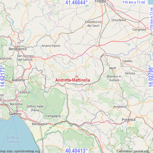
Andretta-Mattinella GPS coordinates[2]
40° 56' 14.712" North, 15° 19' 29.46" East
| Map corner | latitude | longitude |
|---|---|---|
| Upper-left | 41.46644°, | 14.62173° |
| Center: | 40.93742°, | 15.32485° |
| Lower-right: | 40.40413°, | 16.02798° |
| Map W x H: | 118.1×118.1 km | = 73.4×73.4mi |
| max Lat: | 47.04031° ⇑79.3% North |
| Andretta-Mattinella: | 40.93742° |
| min Lat: | ⇓20.7% South 35.50142° |
| min Long | Andretta-Mattin | max Long |
| 6.69888° | 15.32485° | 18.48682° |
| W 89.7%⇐ | ⇒10.3% E |
Elevation
Elevation of Andretta-Mattinella is 806 m = 2644 ft, and this is 499.3 m = 1638 ft above average elevation for this country.
| Max E: |
2085 m = 6841 ft | 6.9% |
| Andretta-Mattinella | 806 m 2644 ft | |
| Avg. | 306.7 m = 1006 ft | |
Min E: |
-4 m = -13 ft | 93.1% |
See also: Italy elevation on elevation.city.
Geographical zone
Andretta-Mattinella is located in North temperate zone (between Tropic of Cancer and the Arctic Circle). Distance of this Northern Tropic circle is 1945.9 km =1209.1 mi to South.| Distance of | km | miles | from Andretta-Mattinella |
|---|---|---|---|
| North Pole | 5455.2 | 3389.7 | to North |
| Arctic Circle | 2849.4 | 1770.5 | to North |
| Tropic Cancer | 1945.9 | 1209.1 | to South |
| Equator | 4551.8 | 2828.4 | to South |


Nearby cities:
15 places around Andretta-Mattinella: (largest is in red/bold)
• Bisaccia
9.1 km =5.7 mi,  28°
28°
• Bisaccia Nuova
8.4 km =5.2 mi,  17°
17°
• Cairano
6 km =3.7 mi,  140°
140°
• Calitri
6.8 km =4.2 mi,  101°
101°
• Castelnuovo di Conza
13 km =8.1 mi,  182°
182°
• Centro Urbano
13.1 km =8.1 mi, 181°
• Guardia Lombardi
9.9 km =6.2 mi,  279°
279°
• Morra de Sanctis
7 km =4.3 mi,  262°
262°
• Nuova Conza della Campania
8.8 km =5.5 mi,  173°
173°
• Pescopagano
13 km =8.1 mi,  151°
151°
• Rocca San Felice
13.4 km =8.3 mi, 276°
• Sant'Andrea di Conza
11 km =6.8 mi,  159°
159°
• Sant'Angelo dei Lombardi
12.6 km =7.8 mi,  265°
265°
• Teora
11.2 km =7 mi,  212°
212°
• Vallata
12.9 km =8 mi,  332°
332°
Sources, notices
• [Note1] Compared only with cities in Italy existing in our database
• [Src1] Map data: © OpenStreetMap contributors (CC-BY-SA)
• [Src2] Other city data from geonames.org with taken over terms of usage.
• [Src3] Geographical zone / Annual Mean Temperature by Robert A. Rohde @ Wikipedia
