Altidona geodata
Altidona (The Marches) is a seat of a third-order administrative division; located in Italy in Europe/Rome (GMT+2) time zone. With population of 345 people, there are 10499 cities with bigger population in this country. Compared to other cities in Italy, 62.5% of cities are located further ↑North; 76.6% of cities are located further ←West and 54.6% of cities have higher elevation than Altidona. Note1


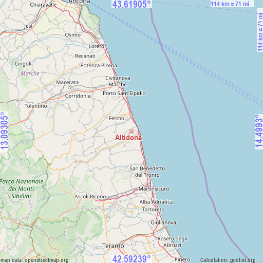
Altidona GPS coordinates[2]
43° 6' 28.332" North, 13° 47' 46.212" East
| Map corner | latitude | longitude |
|---|---|---|
| Upper-left | 43.61905°, | 13.09305° |
| Center: | 43.10787°, | 13.79617° |
| Lower-right: | 42.59239°, | 14.4993° |
| Map W x H: | 114.2×114.2 km | = 71×71mi |
| max Lat: | 47.04031° ⇑62.5% North |
| Altidona: | 43.10787° |
| min Lat: | ⇓37.5% South 35.50142° |
| min Long | Altidona | max Long |
| 6.69888° | 13.79617° | 18.48682° |
| W 76.6%⇐ | ⇒23.4% E |
Elevation
Elevation of Altidona is 205 m = 673 ft, and this is 101.7 m = 334 ft below average elevation for this country.
| Max E: |
2085 m = 6841 ft | 54.6% |
| Avg. | 306.7 m = 1006 ft | |
| Altidona | 205 m = 673 ft | |
Min E: |
-4 m = -13 ft | 45.4% |
See also: Italy elevation on elevation.city.
Geographical zone
Altidona is located in North temperate zone (between Tropic of Cancer and the Arctic Circle). Distance of this Northern Tropic circle is 2187.2 km =1359.1 mi to South.| Distance of | km | miles | from Altidona |
|---|---|---|---|
| North Pole | 5213.9 | 3239.8 | to North |
| Arctic Circle | 2608 | 1620.5 | to North |
| Tropic Cancer | 2187.2 | 1359.1 | to South |
| Equator | 4793.1 | 2978.3 | to South |


Nearby cities:
15 places around Altidona: (largest is in red/bold)
• Campofilone
3.6 km =2.2 mi,  145°
145°
• Fermo
8.5 km =5.3 mi,  315°
315°
• Lapedona
2.1 km =1.3 mi,  274°
274°
• Marina Palmense
4.5 km =2.8 mi,  16°
16°
• Marina di Altidona
3.1 km =1.9 mi,  93°
93°
• Massignano
6.4 km =4 mi,  178°
178°
• Montefiore dell'Aso
7 km =4.3 mi,  208°
208°
• Monterubbiano
6.7 km =4.2 mi,  248°
248°
• Moresco
5.8 km =3.6 mi, 246°
• Pedaso
3.8 km =2.4 mi,  106°
106°
• Ponte Ete-Caldarette
7.3 km =4.5 mi,  298°
298°
• Porto San Giorgio
7.8 km =4.8 mi,  358°
358°
• Rubbianello
8.5 km =5.3 mi,  231°
231°
• Salvano
5.8 km =3.6 mi, 356°
• Valdaso
3.2 km =2 mi, 114°
Sources, notices
• [Note1] Compared only with cities in Italy existing in our database
• [Src1] Map data: © OpenStreetMap contributors (CC-BY-SA)
• [Src2] Other city data from geonames.org with taken over terms of usage.
• [Src3] Geographical zone / Annual Mean Temperature by Robert A. Rohde @ Wikipedia
