Massignano geodata
Massignano (The Marches) is a seat of a third-order administrative division; located in Italy in Europe/Rome (GMT+2) time zone. With population of 492 people, there are 9957 cities with bigger population in this country. Compared to other cities in Italy, 63% of cities are located further ↑North; 76.6% of cities are located further ←West and 50.3% of cities have higher elevation than Massignano. Note1
Administrative division(s):
- Level 1: The Marches
- Level 2: Provincia di Ascoli Piceno
- Level 3: Massignano


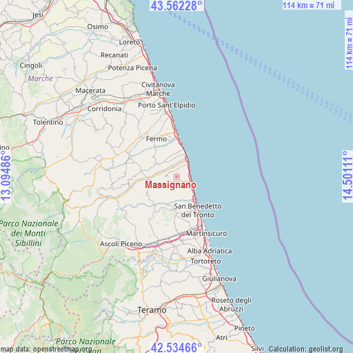
Massignano GPS coordinates[2]
43° 3' 2.232" North, 13° 47' 52.728" East
| Map corner | latitude | longitude |
|---|---|---|
| Upper-left | 43.56228°, | 13.09486° |
| Center: | 43.05062°, | 13.79798° |
| Lower-right: | 42.53466°, | 14.50111° |
| Map W x H: | 114.3×114.3 km | = 71×71mi |
| max Lat: | 47.04031° ⇑63% North |
| Massignano: | 43.05062° |
| min Lat: | ⇓37% South 35.50142° |
| min Long | Massignano | max Long |
| 6.69888° | 13.79798° | 18.48682° |
| W 76.6%⇐ | ⇒23.4% E |
Elevation
Elevation of Massignano is 233 m = 764 ft, and this is 73.7 m = 242 ft below average elevation for this country.
| Max E: |
2085 m = 6841 ft | 50.3% |
| Avg. | 306.7 m = 1006 ft | |
| Massignano | 233 m = 764 ft | |
Min E: |
-4 m = -13 ft | 49.7% |
See also: Italy elevation on elevation.city.
Geographical zone
Massignano is located in North temperate zone (between Tropic of Cancer and the Arctic Circle). Distance of this Northern Tropic circle is 2180.9 km =1355.1 mi to South.| Distance of | km | miles | from Massignano |
|---|---|---|---|
| North Pole | 5220.3 | 3243.7 | to North |
| Arctic Circle | 2614.4 | 1624.5 | to North |
| Tropic Cancer | 2180.9 | 1355.1 | to South |
| Equator | 4786.8 | 2974.4 | to South |


Nearby cities:
15 places around Massignano: (largest is in red/bold)
• Altidona
6.4 km =4 mi,  358°
358°
• Campofilone
3.9 km =2.4 mi,  29°
29°
• Carassai
9.2 km =5.7 mi,  257°
257°
• Cupra Marittima
6.3 km =3.9 mi,  124°
124°
• Grottammare
9.5 km =5.9 mi,  143°
143°
• Lapedona
6.9 km =4.3 mi,  341°
341°
• Marina Palmense
10.7 km =6.6 mi,  5°
5°
• Marina di Altidona
6.8 km =4.2 mi, 25°
• Montefiore dell'Aso
3.5 km =2.2 mi,  273°
273°
• Monterubbiano
7.5 km =4.7 mi,  301°
301°
• Moresco
6.8 km =4.2 mi,  306°
306°
• Pedaso
6.4 km =4 mi, 33°
• Ripatransone
6.3 km =3.9 mi,  207°
207°
• Rubbianello
6.9 km =4.3 mi,  278°
278°
• Valdaso
5.7 km =3.5 mi, 28°
Sources, notices
• [Note1] Compared only with cities in Italy existing in our database
• [Src1] Map data: © OpenStreetMap contributors (CC-BY-SA)
• [Src2] Other city data from geonames.org with taken over terms of usage.
• [Src3] Geographical zone / Annual Mean Temperature by Robert A. Rohde @ Wikipedia
