Alpette geodata
Alpette (Piedmont) is a seat of a third-order administrative division; located in Italy in Europe/Rome (GMT+2) time zone. With population of 239 people, there are 10939 cities with bigger population in this country. Compared to other cities in Italy, 70.5% of cities are located further ↓South; 97.3% of cities are located further →East and 96.5% of cities have lower elevation than Alpette. Note1


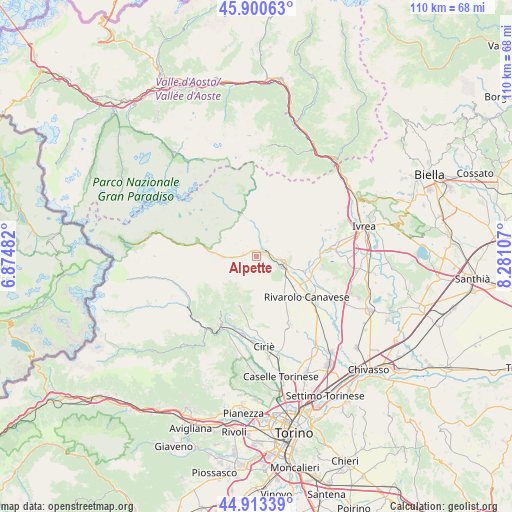
Alpette GPS coordinates[2]
45° 24' 33.012" North, 7° 34' 40.62" East
| Map corner | latitude | longitude |
|---|---|---|
| Upper-left | 45.90063°, | 6.87482° |
| Center: | 45.40917°, | 7.57795° |
| Lower-right: | 44.91339°, | 8.28107° |
| Map W x H: | 109.8×109.8 km | = 68.2×68.2mi |
| max Lat: | 47.04031° ⇑29.5% North |
| Alpette: | 45.40917° |
| min Lat: | ⇓70.5% South 35.50142° |
| min Long | Alpette | max Long |
| 6.69888° | 7.57795° | 18.48682° |
| W 2.7%⇐ | ⇒97.3% E |
Elevation
Elevation of Alpette is 959 m = 3146 ft, and this is 652.3 m = 2140 ft above average elevation for this country.
| Max E: |
2085 m = 6841 ft | 3.5% |
| Alpette | 959 m 3146 ft | |
| Avg. | 306.7 m = 1006 ft | |
Min E: |
-4 m = -13 ft | 96.5% |
See also: Italy elevation on elevation.city.
Geographical zone
Alpette is located in North temperate zone (between Tropic of Cancer and the Arctic Circle). Distance of this North polar circle is 2352.1 km =1461.5 mi to North.| Distance of | km | miles | from Alpette |
|---|---|---|---|
| North Pole | 4958 | 3080.8 | to North |
| Arctic Circle | 2352.1 | 1461.5 | to North |
| Tropic Cancer | 2443.1 | 1518.1 | to South |
| Equator | 5049 | 3137.3 | to South |


Nearby cities:
15 places around Alpette: (largest is in red/bold)
• Borgiallo
7.2 km =4.5 mi,  82°
82°
• Canischio
4.1 km =2.5 mi,  159°
159°
• Chiesanuova
6.1 km =3.8 mi, 81°
• Cuorgnè
5.9 km =3.7 mi,  107°
107°
• Forno Canavese
7.4 km =4.6 mi,  173°
173°
• Frassinetto
4 km =2.5 mi,  36°
36°
• Ingria
6.4 km =4 mi,  355°
355°
• Pertusio
7.7 km =4.8 mi,  140°
140°
• Pont-Canavese
2.2 km =1.4 mi,  52°
52°
• Prascorsano
5.6 km =3.5 mi,  146°
146°
• Pratiglione
6.4 km =4 mi, 167°
• Ribordone
6.5 km =4 mi,  293°
293°
• San Colombano Belmonte
4.5 km =2.8 mi,  131°
131°
• Sparone
2.6 km =1.6 mi,  282°
282°
• Valperga
7.8 km =4.8 mi,  123°
123°
Sources, notices
• [Note1] Compared only with cities in Italy existing in our database
• [Src1] Map data: © OpenStreetMap contributors (CC-BY-SA)
• [Src2] Other city data from geonames.org with taken over terms of usage.
• [Src3] Geographical zone / Annual Mean Temperature by Robert A. Rohde @ Wikipedia
