Almese-Rivera geodata
Almese-Rivera (Piedmont) is a seat of a third-order administrative division; located in Italy in Europe/Rome (GMT+2) time zone. With population of 5,009 people, there are 1950 cities with bigger population in this country. Compared to other cities in Italy, 62.9% of cities are located further ↓South; 98.3% of cities are located further →East and 72.6% of cities have lower elevation than Almese-Rivera. Note1


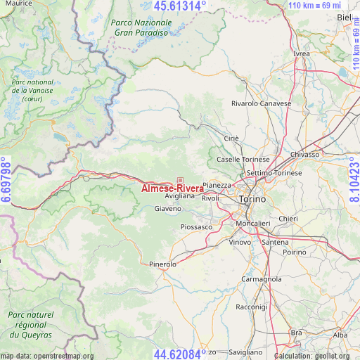
Almese-Rivera GPS coordinates[2]
45° 7' 8.94" North, 7° 24' 3.996" East
| Map corner | latitude | longitude |
|---|---|---|
| Upper-left | 45.61314°, | 6.69798° |
| Center: | 45.11915°, | 7.40111° |
| Lower-right: | 44.62084°, | 8.10423° |
| Map W x H: | 110.3×110.3 km | = 68.5×68.5mi |
| max Lat: | 47.04031° ⇑37.1% North |
| Almese-Rivera: | 45.11915° |
| min Lat: | ⇓62.9% South 35.50142° |
| min Long | Almese-Rivera | max Long |
| 6.69888° | 7.40111° | 18.48682° |
| W 1.7%⇐ | ⇒98.3% E |
Elevation
Elevation of Almese-Rivera is 421 m = 1381 ft, and this is 114.3 m = 375 ft above average elevation for this country.
| Max E: |
2085 m = 6841 ft | 27.4% |
| Almese-Rivera | 421 m 1381 ft | |
| Avg. | 306.7 m = 1006 ft | |
Min E: |
-4 m = -13 ft | 72.6% |
See also: Italy elevation on elevation.city.
Geographical zone
Almese-Rivera is located in North temperate zone (between Tropic of Cancer and the Arctic Circle). Distance of this North polar circle is 2384.4 km =1481.6 mi to North.| Distance of | km | miles | from Almese-Rivera |
|---|---|---|---|
| North Pole | 4990.3 | 3100.8 | to North |
| Arctic Circle | 2384.4 | 1481.6 | to North |
| Tropic Cancer | 2410.9 | 1498.1 | to South |
| Equator | 5016.8 | 3117.3 | to South |


Nearby cities:
15 places around Almese-Rivera: (largest is in red/bold)
• Avigliana
4.4 km =2.7 mi,  184°
184°
• Buttigliera Alta
6.2 km =3.9 mi,  156°
156°
• Caprie
5.3 km =3.3 mi,  270°
270°
• Caselette
6.7 km =4.2 mi,  98°
98°
• Chiusa di San Michele
6 km =3.7 mi,  254°
254°
• Condove
7.3 km =4.5 mi, 267°
• Drubiaglio-Grangia
3 km =1.9 mi,  151°
151°
• Ferriera
4.5 km =2.8 mi, 149°
• Milanere
3 km =1.9 mi,  122°
122°
• Montelera
5.1 km =3.2 mi,  39°
39°
• Novaretto
3.6 km =2.2 mi, 267°
• Rubiana
2.3 km =1.4 mi,  325°
325°
• Sant'Ambrogio di Torino
3.8 km =2.4 mi,  227°
227°
• Val della Torre
5.3 km =3.3 mi, 40°
• Villar Dora
1.5 km =0.9 mi, 250°
Sources, notices
• [Note1] Compared only with cities in Italy existing in our database
• [Src1] Map data: © OpenStreetMap contributors (CC-BY-SA)
• [Src2] Other city data from geonames.org with taken over terms of usage.
• [Src3] Geographical zone / Annual Mean Temperature by Robert A. Rohde @ Wikipedia
