Agugliano geodata
Agugliano (The Marches) is a seat of a third-order administrative division; located in Italy in Europe/Rome (GMT+2) time zone. With population of 3,465 people, there are 2706 cities with bigger population in this country. Compared to other cities in Italy, 59.5% of cities are located further ↑North; 72.2% of cities are located further ←West and 55.9% of cities have higher elevation than Agugliano. Note1


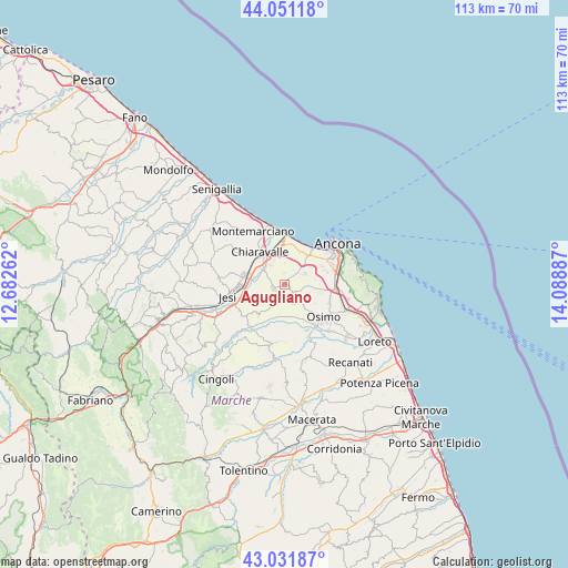
Agugliano GPS coordinates[2]
43° 32' 37.248" North, 13° 23' 8.664" East
| Map corner | latitude | longitude |
|---|---|---|
| Upper-left | 44.05118°, | 12.68262° |
| Center: | 43.54368°, | 13.38574° |
| Lower-right: | 43.03187°, | 14.08887° |
| Map W x H: | 113.3×113.3 km | = 70.4×70.4mi |
| max Lat: | 47.04031° ⇑59.5% North |
| Agugliano: | 43.54368° |
| min Lat: | ⇓40.5% South 35.50142° |
| min Long | Agugliano | max Long |
| 6.69888° | 13.38574° | 18.48682° |
| W 72.2%⇐ | ⇒27.8% E |
Elevation
Elevation of Agugliano is 196 m = 643 ft, and this is 110.7 m = 363 ft below average elevation for this country.
| Max E: |
2085 m = 6841 ft | 55.9% |
| Avg. | 306.7 m = 1006 ft | |
| Agugliano | 196 m = 643 ft | |
Min E: |
-4 m = -13 ft | 44.1% |
See also: Italy elevation on elevation.city.
Geographical zone
Agugliano is located in North temperate zone (between Tropic of Cancer and the Arctic Circle). Distance of this Northern Tropic circle is 2235.7 km =1389.2 mi to South.| Distance of | km | miles | from Agugliano |
|---|---|---|---|
| North Pole | 5165.5 | 3209.7 | to North |
| Arctic Circle | 2559.6 | 1590.5 | to North |
| Tropic Cancer | 2235.7 | 1389.2 | to South |
| Equator | 4841.6 | 3008.4 | to South |


Nearby cities:
15 places around Agugliano: (largest is in red/bold)
• Aspio
9.3 km =5.8 mi,  96°
96°
• Borghetto
9.7 km =6 mi,  308°
308°
• Camerata Picena
4.6 km =2.9 mi,  324°
324°
• Candia
9 km =5.6 mi,  74°
74°
• Chiaravalle
8 km =5 mi, 322°
• Falconara Marittima
9.2 km =5.7 mi,  6°
6°
• Le Cozze
8.2 km =5.1 mi, 315°
• Offagna
4.9 km =3 mi,  114°
114°
• Osimo
10.1 km =6.3 mi,  129°
129°
• Piane
5.5 km =3.4 mi, 319°
• Pinocchio di Ancona
10.1 km =6.3 mi,  59°
59°
• Polverigi
1.7 km =1.1 mi,  187°
187°
• Ponte dell'Aspio
9.3 km =5.8 mi, 99°
• San Biagio
9.4 km =5.8 mi, 109°
• Santa Maria Nuova
7.6 km =4.7 mi,  220°
220°
Sources, notices
• [Note1] Compared only with cities in Italy existing in our database
• [Src1] Map data: © OpenStreetMap contributors (CC-BY-SA)
• [Src2] Other city data from geonames.org with taken over terms of usage.
• [Src3] Geographical zone / Annual Mean Temperature by Robert A. Rohde @ Wikipedia
