Offagna geodata
Offagna (The Marches) is a seat of a third-order administrative division; located in Italy in Europe/Rome (GMT+2) time zone. With population of 1,386 people, there are 5395 cities with bigger population in this country. Compared to other cities in Italy, 59.6% of cities are located further ↑North; 72.9% of cities are located further ←West and 55.7% of cities have lower elevation than Offagna. Note1


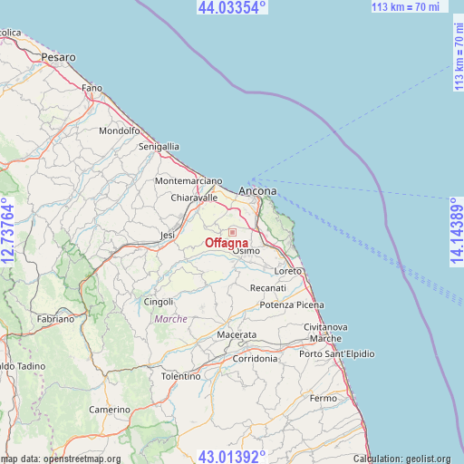
Offagna GPS coordinates[2]
43° 31' 33.168" North, 13° 26' 26.736" East
| Map corner | latitude | longitude |
|---|---|---|
| Upper-left | 44.03354°, | 12.73764° |
| Center: | 43.52588°, | 13.44076° |
| Lower-right: | 43.01392°, | 14.14389° |
| Map W x H: | 113.4×113.4 km | = 70.5×70.5mi |
| max Lat: | 47.04031° ⇑59.6% North |
| Offagna: | 43.52588° |
| min Lat: | ⇓40.4% South 35.50142° |
| min Long | Offagna | max Long |
| 6.69888° | 13.44076° | 18.48682° |
| W 72.9%⇐ | ⇒27.1% E |
Elevation
Elevation of Offagna is 270 m = 886 ft, and this is 36.7 m = 120 ft below average elevation for this country.
| Max E: |
2085 m = 6841 ft | 44.3% |
| Avg. | 306.7 m = 1006 ft | |
| Offagna | 270 m = 886 ft | |
Min E: |
-4 m = -13 ft | 55.7% |
See also: Italy elevation on elevation.city.
Geographical zone
Offagna is located in North temperate zone (between Tropic of Cancer and the Arctic Circle). Distance of this Northern Tropic circle is 2233.7 km =1388 mi to South.| Distance of | km | miles | from Offagna |
|---|---|---|---|
| North Pole | 5167.4 | 3210.9 | to North |
| Arctic Circle | 2561.5 | 1591.6 | to North |
| Tropic Cancer | 2233.7 | 1388 | to South |
| Equator | 4839.6 | 3007.2 | to South |


Nearby cities:
15 places around Offagna: (largest is in red/bold)
• Abbadia
8.8 km =5.5 mi,  118°
118°
• Agugliano
4.9 km =3 mi,  294°
294°
• Aspio
4.9 km =3 mi,  79°
79°
• Camerano
9 km =5.6 mi,  88°
88°
• Campocavallo
8.5 km =5.3 mi,  147°
147°
• Candia
6.1 km =3.8 mi,  43°
43°
• Montoro
8.2 km =5.1 mi,  195°
195°
• Osimo
5.6 km =3.5 mi,  143°
143°
• Padiglione
6.6 km =4.1 mi,  164°
164°
• Pinocchio di Ancona
8.3 km =5.2 mi,  31°
31°
• Polverigi
4.7 km =2.9 mi,  273°
273°
• Ponte dell'Aspio
4.7 km =2.9 mi, 85°
• Posatora
9.1 km =5.7 mi, 25°
• San Biagio
4.6 km =2.9 mi,  103°
103°
• San Sabino
8.1 km =5 mi, 135°
Sources, notices
• [Note1] Compared only with cities in Italy existing in our database
• [Src1] Map data: © OpenStreetMap contributors (CC-BY-SA)
• [Src2] Other city data from geonames.org with taken over terms of usage.
• [Src3] Geographical zone / Annual Mean Temperature by Robert A. Rohde @ Wikipedia
