Agrano geodata
Agrano (Piedmont) is a populated place; located in Italy in Europe/Rome (GMT+2) time zone. With population of 682 people, there are 8413 cities with bigger population in this country. Compared to other cities in Italy, 87.6% of cities are located further ↓South; 88.9% of cities are located further →East and 75.9% of cities have lower elevation than Agrano. Note1
Administrative division(s):
- Level 1: Piedmont
- Level 2: Provincia Verbano-Cusio-Ossola
- Level 3: Omegna


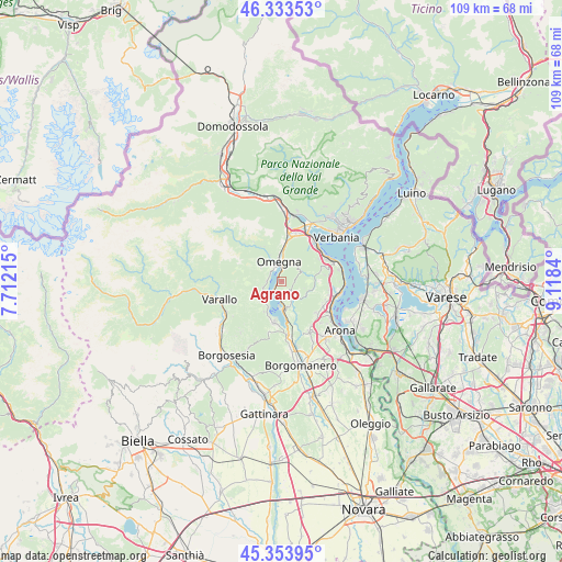
Agrano GPS coordinates[2]
45° 50' 45.24" North, 8° 24' 54.972" East
| Map corner | latitude | longitude |
|---|---|---|
| Upper-left | 46.33353°, | 7.71215° |
| Center: | 45.8459°, | 8.41527° |
| Lower-right: | 45.35395°, | 9.1184° |
| Map W x H: | 108.9×108.9 km | = 67.7×67.7mi |
| max Lat: | 47.04031° ⇑12.4% North |
| Agrano: | 45.8459° |
| min Lat: | ⇓87.6% South 35.50142° |
| min Long | Agrano | max Long |
| 6.69888° | 8.41527° | 18.48682° |
| W 11.1%⇐ | ⇒88.9% E |
Elevation
Elevation of Agrano is 463 m = 1519 ft, and this is 156.3 m = 513 ft above average elevation for this country.
| Max E: |
2085 m = 6841 ft | 24.1% |
| Agrano | 463 m 1519 ft | |
| Avg. | 306.7 m = 1006 ft | |
Min E: |
-4 m = -13 ft | 75.9% |
See also: Italy elevation on elevation.city.
Geographical zone
Agrano is located in North temperate zone (between Tropic of Cancer and the Arctic Circle). Distance of this North polar circle is 2303.6 km =1431.4 mi to North.| Distance of | km | miles | from Agrano |
|---|---|---|---|
| North Pole | 4909.5 | 3050.6 | to North |
| Arctic Circle | 2303.6 | 1431.4 | to North |
| Tropic Cancer | 2491.7 | 1548.3 | to South |
| Equator | 5097.6 | 3167.5 | to South |


Nearby cities:
15 places around Agrano: (largest is in red/bold)
• Ameno
6.6 km =4.1 mi,  163°
163°
• Armeno
3.6 km =2.2 mi,  139°
139°
• Arola
6.1 km =3.8 mi,  226°
226°
• Cesara
3.9 km =2.4 mi,  249°
249°
• Gabbio-Cereda-Ramate
7.1 km =4.4 mi,  3°
3°
• Germagno
5.6 km =3.5 mi,  337°
337°
• Madonna del Sasso
6.9 km =4.3 mi,  210°
210°
• Miasino
5 km =3.1 mi,  167°
167°
• Nonio
2.9 km =1.8 mi,  269°
269°
• Omegna
3.9 km =2.4 mi,  350°
350°
• Orta San Giulio
5.4 km =3.4 mi,  180°
180°
• Pella
5.9 km =3.7 mi,  203°
203°
• Pettenasco
3.3 km =2.1 mi,  191°
191°
• Quarna Sopra
4.4 km =2.7 mi,  313°
313°
• Quarna Sotto
4.8 km =3 mi,  302°
302°
Sources, notices
• [Note1] Compared only with cities in Italy existing in our database
• [Src1] Map data: © OpenStreetMap contributors (CC-BY-SA)
• [Src2] Other city data from geonames.org with taken over terms of usage.
• [Src3] Geographical zone / Annual Mean Temperature by Robert A. Rohde @ Wikipedia
