Agosta geodata
Agosta (Latium) is a seat of a third-order administrative division; located in Italy in Europe/Rome (GMT+2) time zone. With population of 1,054 people, there are 6457 cities with bigger population in this country. Compared to other cities in Italy, 70.5% of cities are located further ↑North; 68.6% of cities are located further ←West and 65.9% of cities have lower elevation than Agosta. Note1
Administrative division(s):
- Level 1: Latium
- Level 2: Città metropolitana di Roma Capitale
- Level 3: Agosta


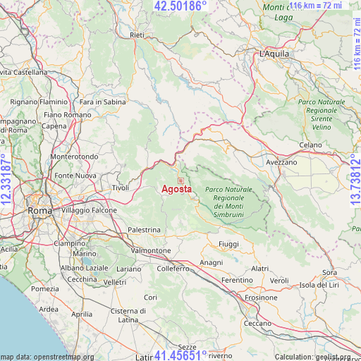
Agosta GPS coordinates[2]
41° 58' 52.788" North, 13° 2' 5.964" East
| Map corner | latitude | longitude |
|---|---|---|
| Upper-left | 42.50186°, | 12.33187° |
| Center: | 41.98133°, | 13.03499° |
| Lower-right: | 41.45651°, | 13.73812° |
| Map W x H: | 116.2×116.2 km | = 72.2×72.2mi |
| max Lat: | 47.04031° ⇑70.5% North |
| Agosta: | 41.98133° |
| min Lat: | ⇓29.5% South 35.50142° |
| min Long | Agosta | max Long |
| 6.69888° | 13.03499° | 18.48682° |
| W 68.6%⇐ | ⇒31.4% E |
Elevation
Elevation of Agosta is 352 m = 1155 ft, and this is 45.3 m = 149 ft above average elevation for this country.
| Max E: |
2085 m = 6841 ft | 34.1% |
| Agosta | 352 m 1155 ft | |
| Avg. | 306.7 m = 1006 ft | |
Min E: |
-4 m = -13 ft | 65.9% |
See also: Italy elevation on elevation.city.
Geographical zone
Agosta is located in North temperate zone (between Tropic of Cancer and the Arctic Circle). Distance of this Northern Tropic circle is 2062 km =1281.3 mi to South.| Distance of | km | miles | from Agosta |
|---|---|---|---|
| North Pole | 5339.2 | 3317.6 | to North |
| Arctic Circle | 2733.3 | 1698.4 | to North |
| Tropic Cancer | 2062 | 1281.3 | to South |
| Equator | 4667.9 | 2900.5 | to South |


Nearby cities:
15 places around Agosta: (largest is in red/bold)
• Anticoli Corrado
4.7 km =2.9 mi,  308°
308°
• Arsoli
6.9 km =4.3 mi,  346°
346°
• Camerata Nuova
7.4 km =4.6 mi,  56°
56°
• Canterano
4.2 km =2.6 mi,  176°
176°
• Cerreto Laziale
6.1 km =3.8 mi,  226°
226°
• Cervara di Roma
2.8 km =1.7 mi,  74°
74°
• Gerano
6.4 km =4 mi,  215°
215°
• Marano Equo
2.3 km =1.4 mi, 313°
• Oricola
7.6 km =4.7 mi,  2°
2°
• Rocca Canterano
3 km =1.9 mi,  201°
201°
• Rocca Santo Stefano
7.9 km =4.9 mi,  186°
186°
• Rocca di Botte
6.3 km =3.9 mi,  28°
28°
• Roviano
6.1 km =3.8 mi,  325°
325°
• Saracinesco
7.2 km =4.5 mi,  289°
289°
• Subiaco
7.6 km =4.7 mi,  143°
143°
Sources, notices
• [Note1] Compared only with cities in Italy existing in our database
• [Src1] Map data: © OpenStreetMap contributors (CC-BY-SA)
• [Src2] Other city data from geonames.org with taken over terms of usage.
• [Src3] Geographical zone / Annual Mean Temperature by Robert A. Rohde @ Wikipedia
