Cervara di Roma geodata
Cervara di Roma (Latium) is a seat of a third-order administrative division; located in Italy in Europe/Rome (GMT+2) time zone. With population of 202 people, there are 11123 cities with bigger population in this country. Compared to other cities in Italy, 70.4% of cities are located further ↑North; 69% of cities are located further ←West and 97.5% of cities have lower elevation than Cervara di Roma. Note1
Administrative division(s):
- Level 1: Latium
- Level 2: Città metropolitana di Roma Capitale
- Level 3: Cervara di Roma


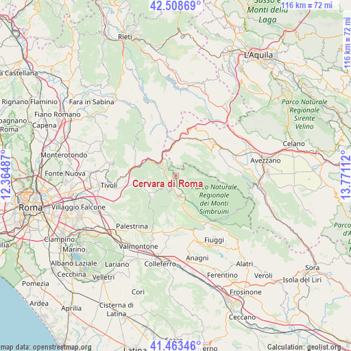
Cervara di Roma GPS coordinates[2]
41° 59' 17.592" North, 13° 4' 4.764" East
| Map corner | latitude | longitude |
|---|---|---|
| Upper-left | 42.50869°, | 12.36487° |
| Center: | 41.98822°, | 13.06799° |
| Lower-right: | 41.46346°, | 13.77112° |
| Map W x H: | 116.2×116.2 km | = 72.2×72.2mi |
| max Lat: | 47.04031° ⇑70.4% North |
| Cervara di Roma: | 41.98822° |
| min Lat: | ⇓29.6% South 35.50142° |
| min Long | Cervara di Roma | max Long |
| 6.69888° | 13.06799° | 18.48682° |
| W 69%⇐ | ⇒31% E |
Elevation
Elevation of Cervara di Roma is 1038 m = 3406 ft, and this is 731.3 m = 2399 ft above average elevation for this country.
| Max E: |
2085 m = 6841 ft | 2.5% |
| Cervara di Roma | 1038 m 3406 ft | |
| Avg. | 306.7 m = 1006 ft | |
Min E: |
-4 m = -13 ft | 97.5% |
See also: Italy elevation on elevation.city.
Geographical zone
Cervara di Roma is located in North temperate zone (between Tropic of Cancer and the Arctic Circle). Distance of this Northern Tropic circle is 2062.7 km =1281.7 mi to South.| Distance of | km | miles | from Cervara di Roma |
|---|---|---|---|
| North Pole | 5338.4 | 3317.1 | to North |
| Arctic Circle | 2732.5 | 1697.9 | to North |
| Tropic Cancer | 2062.7 | 1281.7 | to South |
| Equator | 4668.7 | 2901 | to South |


Nearby cities:
15 places around Cervara di Roma: (largest is in red/bold)
• Agosta
2.8 km =1.7 mi,  254°
254°
• Anticoli Corrado
6.8 km =4.2 mi,  288°
288°
• Arsoli
7.3 km =4.5 mi,  324°
324°
• Camerata Nuova
4.8 km =3 mi,  46°
46°
• Canterano
5.6 km =3.5 mi,  206°
206°
• Cerreto Laziale
8.7 km =5.4 mi,  235°
235°
• Gerano
8.8 km =5.5 mi,  227°
227°
• Marano Equo
4.4 km =2.7 mi,  280°
280°
• Oricola
7.2 km =4.5 mi,  340°
340°
• Pereto
8.3 km =5.2 mi,  20°
20°
• Rocca Canterano
5.2 km =3.2 mi, 227°
• Rocca Santo Stefano
9.4 km =5.8 mi,  202°
202°
• Rocca di Botte
4.8 km =3 mi,  3°
3°
• Roviano
7.5 km =4.7 mi,  304°
304°
• Subiaco
7.1 km =4.4 mi,  165°
165°
Sources, notices
• [Note1] Compared only with cities in Italy existing in our database
• [Src1] Map data: © OpenStreetMap contributors (CC-BY-SA)
• [Src2] Other city data from geonames.org with taken over terms of usage.
• [Src3] Geographical zone / Annual Mean Temperature by Robert A. Rohde @ Wikipedia
