Agnone geodata
Agnone (Molise) is a seat of a third-order administrative division; located in Italy in Europe/Rome (GMT+2) time zone. With population of 3,978 people, there are 2408 cities with bigger population in this country. Compared to other cities in Italy, 71.9% of cities are located further ↑North; 81.6% of cities are located further ←West and 93.5% of cities have lower elevation than Agnone. Note1


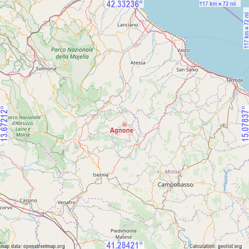
Agnone GPS coordinates[2]
41° 48' 37.548" North, 14° 22' 30.864" East
| Map corner | latitude | longitude |
|---|---|---|
| Upper-left | 42.33236°, | 13.67212° |
| Center: | 41.81043°, | 14.37524° |
| Lower-right: | 41.28421°, | 15.07837° |
| Map W x H: | 116.5×116.5 km | = 72.4×72.4mi |
| max Lat: | 47.04031° ⇑71.9% North |
| Agnone: | 41.81043° |
| min Lat: | ⇓28.1% South 35.50142° |
| min Long | Agnone | max Long |
| 6.69888° | 14.37524° | 18.48682° |
| W 81.6%⇐ | ⇒18.4% E |
Elevation
Elevation of Agnone is 817 m = 2680 ft, and this is 510.3 m = 1674 ft above average elevation for this country.
| Max E: |
2085 m = 6841 ft | 6.5% |
| Agnone | 817 m 2680 ft | |
| Avg. | 306.7 m = 1006 ft | |
Min E: |
-4 m = -13 ft | 93.5% |
See also: Italy elevation on elevation.city.
Geographical zone
Agnone is located in North temperate zone (between Tropic of Cancer and the Arctic Circle). Distance of this Northern Tropic circle is 2043 km =1269.5 mi to South.| Distance of | km | miles | from Agnone |
|---|---|---|---|
| North Pole | 5358.2 | 3329.4 | to North |
| Arctic Circle | 2752.3 | 1710.2 | to North |
| Tropic Cancer | 2043 | 1269.5 | to South |
| Equator | 4648.9 | 2888.7 | to South |


Nearby cities:
15 places around Agnone: (largest is in red/bold)
• Belmonte del Sannio
4.2 km =2.6 mi,  69°
69°
• Capracotta
9.4 km =5.8 mi,  285°
285°
• Carovilli
12.7 km =7.9 mi,  211°
211°
• Castel del Giudice
12.9 km =8 mi, 292°
• Castelguidone
12.3 km =7.6 mi,  83°
83°
• Castelverrino
5.2 km =3.2 mi,  158°
158°
• Castiglione Messer Marino
8.9 km =5.5 mi,  43°
43°
• Pescopennataro
10.1 km =6.3 mi,  318°
318°
• Pietrabbondante
7.3 km =4.5 mi,  173°
173°
• Poggio Sannita
4.8 km =3 mi,  136°
136°
• Roio del Sangro
11.2 km =7 mi,  359°
359°
• Rosello
10.3 km =6.4 mi,  347°
347°
• Sant'Angelo del Pesco
12.8 km =8 mi,  308°
308°
• Schiavi di Abruzzo
9.2 km =5.7 mi,  88°
88°
• Vastogirardi
10.5 km =6.5 mi,  247°
247°
Sources, notices
• [Note1] Compared only with cities in Italy existing in our database
• [Src1] Map data: © OpenStreetMap contributors (CC-BY-SA)
• [Src2] Other city data from geonames.org with taken over terms of usage.
• [Src3] Geographical zone / Annual Mean Temperature by Robert A. Rohde @ Wikipedia
