Capracotta geodata
Capracotta (Molise) is a seat of a third-order administrative division; located in Italy in Europe/Rome (GMT+2) time zone. With population of 872 people, there are 7303 cities with bigger population in this country. Compared to other cities in Italy, 71.8% of cities are located further ↑North; 80.5% of cities are located further ←West and 99.5% of cities have lower elevation than Capracotta. Note1


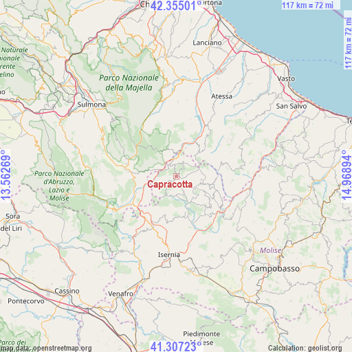
Capracotta GPS coordinates[2]
41° 49' 59.736" North, 14° 15' 56.916" East
| Map corner | latitude | longitude |
|---|---|---|
| Upper-left | 42.35501°, | 13.56269° |
| Center: | 41.83326°, | 14.26581° |
| Lower-right: | 41.30723°, | 14.96894° |
| Map W x H: | 116.5×116.5 km | = 72.4×72.4mi |
| max Lat: | 47.04031° ⇑71.8% North |
| Capracotta: | 41.83326° |
| min Lat: | ⇓28.2% South 35.50142° |
| min Long | Capracotta | max Long |
| 6.69888° | 14.26581° | 18.48682° |
| W 80.5%⇐ | ⇒19.5% E |
Elevation
Elevation of Capracotta is 1384 m = 4541 ft, and this is 1077.3 m = 3534 ft above average elevation for this country.
| Max E: |
2085 m = 6841 ft | 0.5% |
| Capracotta | 1384 m 4541 ft | |
| Avg. | 306.7 m = 1006 ft | |
Min E: |
-4 m = -13 ft | 99.5% |
See also: Italy elevation on elevation.city.
Geographical zone
Capracotta is located in North temperate zone (between Tropic of Cancer and the Arctic Circle). Distance of this Northern Tropic circle is 2045.5 km =1271 mi to South.| Distance of | km | miles | from Capracotta |
|---|---|---|---|
| North Pole | 5355.6 | 3327.8 | to North |
| Arctic Circle | 2749.8 | 1708.6 | to North |
| Tropic Cancer | 2045.5 | 1271 | to South |
| Equator | 4651.4 | 2890.2 | to South |


Nearby cities:
15 places around Capracotta: (largest is in red/bold)
• Agnone
9.4 km =5.8 mi,  105°
105°
• Ateleta
6.1 km =3.8 mi,  292°
292°
• Borrello
9.9 km =6.2 mi,  19°
19°
• Castel del Giudice
3.7 km =2.3 mi,  310°
310°
• Civitaluparella
12.8 km =8 mi,  13°
13°
• Fallo
12.6 km =7.8 mi, 22°
• Gamberale
9.3 km =5.8 mi,  329°
329°
• Pescopennataro
5.5 km =3.4 mi,  25°
25°
• Pizzoferrato
10.2 km =6.3 mi,  346°
346°
• Quadri
10.3 km =6.4 mi, 10°
• Roio del Sangro
12.5 km =7.8 mi,  45°
45°
• Rosello
10.2 km =6.3 mi,  42°
42°
• San Pietro Avellana
8.4 km =5.2 mi,  234°
234°
• Sant'Angelo del Pesco
5.5 km =3.4 mi, 349°
• Vastogirardi
6.6 km =4.1 mi,  185°
185°
Sources, notices
• [Note1] Compared only with cities in Italy existing in our database
• [Src1] Map data: © OpenStreetMap contributors (CC-BY-SA)
• [Src2] Other city data from geonames.org with taken over terms of usage.
• [Src3] Geographical zone / Annual Mean Temperature by Robert A. Rohde @ Wikipedia
