Agnadello geodata
Agnadello (Lombardy) is a seat of a third-order administrative division; located in Italy in Europe/Rome (GMT+2) time zone. With population of 3,605 people, there are 2617 cities with bigger population in this country. Compared to other cities in Italy, 71.8% of cities are located further ↓South; 72.6% of cities are located further →East and 70% of cities have higher elevation than Agnadello. Note1


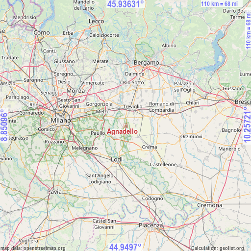
Agnadello GPS coordinates[2]
45° 26' 42.576" North, 9° 33' 14.688" East
| Map corner | latitude | longitude |
|---|---|---|
| Upper-left | 45.93631°, | 8.85096° |
| Center: | 45.44516°, | 9.55408° |
| Lower-right: | 44.9497°, | 10.25721° |
| Map W x H: | 109.7×109.7 km | = 68.2×68.2mi |
| max Lat: | 47.04031° ⇑28.2% North |
| Agnadello: | 45.44516° |
| min Lat: | ⇓71.8% South 35.50142° |
| min Long | Agnadello | max Long |
| 6.69888° | 9.55408° | 18.48682° |
| W 27.4%⇐ | ⇒72.6% E |
Elevation
Elevation of Agnadello is 97 m = 318 ft, and this is 209.7 m = 688 ft below average elevation for this country.
| Max E: |
2085 m = 6841 ft | 70% |
| Avg. | 306.7 m = 1006 ft | |
| Agnadello | 97 m = 318 ft | |
Min E: |
-4 m = -13 ft | 30% |
See also: Italy elevation on elevation.city.
Geographical zone
Agnadello is located in North temperate zone (between Tropic of Cancer and the Arctic Circle). Distance of this North polar circle is 2348.1 km =1459 mi to North.| Distance of | km | miles | from Agnadello |
|---|---|---|---|
| North Pole | 4954 | 3078.3 | to North |
| Arctic Circle | 2348.1 | 1459 | to North |
| Tropic Cancer | 2447.1 | 1520.6 | to South |
| Equator | 5053 | 3139.8 | to South |


Nearby cities:
15 places around Agnadello: (largest is in red/bold)
• Arzago d'Adda
4.1 km =2.5 mi,  11°
11°
• Calvenzano
6.7 km =4.2 mi,  31°
31°
• Capralba
7 km =4.3 mi,  91°
91°
• Cascine San Pietro
7 km =4.3 mi,  345°
345°
• Casirate d'Adda
5.7 km =3.5 mi, 12°
• Misano di Gera d'Adda
5.9 km =3.7 mi,  62°
62°
• Nosadello
5.1 km =3.2 mi,  201°
201°
• Palazzo Pignano
6.2 km =3.9 mi,  168°
168°
• Pandino
4.4 km =2.7 mi,  181°
181°
• Pieranica
4.9 km =3 mi,  115°
115°
• Quintano
5.7 km =3.5 mi, 118°
• Rivolta d'Adda
4.2 km =2.6 mi,  309°
309°
• Scannabue-Cascine Capri
6.5 km =4 mi,  152°
152°
• Torlino Vimercati
4.4 km =2.7 mi,  134°
134°
• Vailate
4.3 km =2.7 mi, 63°
Sources, notices
• [Note1] Compared only with cities in Italy existing in our database
• [Src1] Map data: © OpenStreetMap contributors (CC-BY-SA)
• [Src2] Other city data from geonames.org with taken over terms of usage.
• [Src3] Geographical zone / Annual Mean Temperature by Robert A. Rohde @ Wikipedia
