Vailate geodata
Vailate (Lombardy) is a seat of a third-order administrative division; located in Italy in Europe/Rome (GMT+2) time zone. With population of 4,357 people, there are 2208 cities with bigger population in this country. Compared to other cities in Italy, 72.3% of cities are located further ↓South; 72% of cities are located further →East and 68.3% of cities have higher elevation than Vailate. Note1


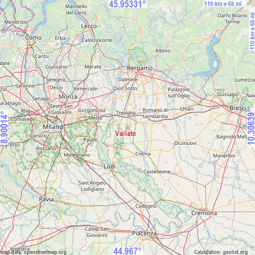
Vailate GPS coordinates[2]
45° 27' 44.316" North, 9° 36' 11.736" East
| Map corner | latitude | longitude |
|---|---|---|
| Upper-left | 45.95331°, | 8.90014° |
| Center: | 45.46231°, | 9.60326° |
| Lower-right: | 44.967°, | 10.30639° |
| Map W x H: | 109.7×109.7 km | = 68.2×68.2mi |
| max Lat: | 47.04031° ⇑27.7% North |
| Vailate: | 45.46231° |
| min Lat: | ⇓72.3% South 35.50142° |
| min Long | Vailate | max Long |
| 6.69888° | 9.60326° | 18.48682° |
| W 28%⇐ | ⇒72% E |
Elevation
Elevation of Vailate is 107 m = 351 ft, and this is 199.7 m = 655 ft below average elevation for this country.
| Max E: |
2085 m = 6841 ft | 68.3% |
| Avg. | 306.7 m = 1006 ft | |
| Vailate | 107 m = 351 ft | |
Min E: |
-4 m = -13 ft | 31.7% |
See also: Italy elevation on elevation.city.
Geographical zone
Vailate is located in North temperate zone (between Tropic of Cancer and the Arctic Circle). Distance of this North polar circle is 2346.2 km =1457.9 mi to North.| Distance of | km | miles | from Vailate |
|---|---|---|---|
| North Pole | 4952.1 | 3077.1 | to North |
| Arctic Circle | 2346.2 | 1457.9 | to North |
| Tropic Cancer | 2449 | 1521.7 | to South |
| Equator | 5054.9 | 3141 | to South |


Nearby cities:
15 places around Vailate: (largest is in red/bold)
• Agnadello
4.3 km =2.7 mi,  243°
243°
• Arzago d'Adda
3.7 km =2.3 mi,  304°
304°
• Calvenzano
3.8 km =2.4 mi,  355°
355°
• Capralba
3.8 km =2.4 mi,  123°
123°
• Caravaggio
4.8 km =3 mi,  38°
38°
• Casaletto Vaprio
6.3 km =3.9 mi,  161°
161°
• Casirate d'Adda
4.5 km =2.8 mi,  324°
324°
• Fornovo San Giovanni
7 km =4.3 mi,  55°
55°
• Misano di Gera d'Adda
1.6 km =1 mi, 60°
• Mozzanica
6.8 km =4.2 mi,  76°
76°
• Pieranica
4.1 km =2.5 mi,  172°
172°
• Quintano
4.8 km =3 mi, 165°
• Torlino Vimercati
5 km =3.1 mi,  187°
187°
• Trescore Cremasco
6.8 km =4.2 mi, 166°
• Treviglio
6.6 km =4.1 mi,  351°
351°
Sources, notices
• [Note1] Compared only with cities in Italy existing in our database
• [Src1] Map data: © OpenStreetMap contributors (CC-BY-SA)
• [Src2] Other city data from geonames.org with taken over terms of usage.
• [Src3] Geographical zone / Annual Mean Temperature by Robert A. Rohde @ Wikipedia
