Rivà geodata
Rivà (Veneto) is a populated place; located in Italy in Europe/Rome (GMT+2) time zone. With population of 792 people, there are 7691 cities with bigger population in this country. Compared to other cities in Italy, 58.5% of cities are located further ↓South; 58.9% of cities are located further ←West and 100% of cities have higher elevation than Rivà. Note1
Administrative division(s):
- Level 1: Veneto
- Level 2: Provincia di Rovigo
- Level 3: Ariano nel Polesine


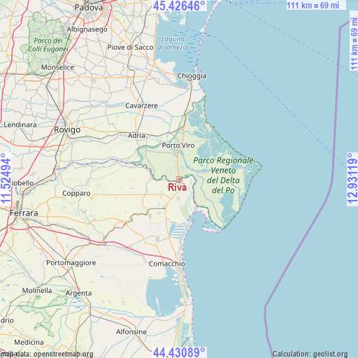
Rivà GPS coordinates[2]
44° 55' 50.988" North, 12° 13' 41.016" East
| Map corner | latitude | longitude |
|---|---|---|
| Upper-left | 45.42646°, | 11.52494° |
| Center: | 44.93083°, | 12.22806° |
| Lower-right: | 44.43089°, | 12.93119° |
| Map W x H: | 110.7×110.7 km | = 68.8×68.8mi |
| max Lat: | 47.04031° ⇑41.5% North |
| Rivà: | 44.93083° |
| min Lat: | ⇓58.5% South 35.50142° |
| min Long | Rivà | max Long |
| 6.69888° | 12.22806° | 18.48682° |
| W 58.9%⇐ | ⇒41.1% E |
Elevation
Elevation of Rivà is -2 m = -7 ft, and this is 308.7 m = 1013 ft below average elevation for this country.
| Max E: |
2085 m = 6841 ft | 100% |
| Avg. | 306.7 m = 1006 ft | |
| Rivà | -2 m = -7 ft | |
Min E: |
-4 m = -13 ft | 0% |
See also: Italy elevation on elevation.city.
Geographical zone
Rivà is located in North temperate zone (between Tropic of Cancer and the Arctic Circle). Distance of this Northern Tropic circle is 2389.9 km =1485 mi to South.| Distance of | km | miles | from Rivà |
|---|---|---|---|
| North Pole | 5011.2 | 3113.8 | to North |
| Arctic Circle | 2405.3 | 1494.6 | to North |
| Tropic Cancer | 2389.9 | 1485 | to South |
| Equator | 4995.8 | 3104.2 | to South |


Nearby cities:
15 places around Rivà: (largest is in red/bold)
• Ariano
8.3 km =5.2 mi,  281°
281°
• Ariano Ferrarese
8.9 km =5.5 mi, 277°
• Bosco Mesola
6.1 km =3.8 mi,  177°
177°
• Ca' Tiepolo
9 km =5.6 mi,  77°
77°
• Donzella
8.1 km =5 mi,  90°
90°
• Goro
10.3 km =6.4 mi,  148°
148°
• Mesola
1.4 km =0.9 mi,  169°
169°
• Mezzogoro
10.6 km =6.6 mi,  252°
252°
• Monticelli
3.8 km =2.4 mi,  241°
241°
• Papozze
7.6 km =4.7 mi,  320°
320°
• Pontelangorino
10 km =6.2 mi,  218°
218°
• Porto Tolle
7.9 km =4.9 mi,  74°
74°
• Porto Viro
10.7 km =6.6 mi,  355°
355°
• Taglio
10.3 km =6.4 mi,  352°
352°
• Taglio di Po
8 km =5 mi, 351°
Sources, notices
• [Note1] Compared only with cities in Italy existing in our database
• [Src1] Map data: © OpenStreetMap contributors (CC-BY-SA)
• [Src2] Other city data from geonames.org with taken over terms of usage.
• [Src3] Geographical zone / Annual Mean Temperature by Robert A. Rohde @ Wikipedia
