Goro geodata
Goro (Emilia-Romagna) is a seat of a third-order administrative division; located in Italy in Europe/Rome (GMT+2) time zone. With population of 3,101 people, there are 2961 cities with bigger population in this country. Compared to other cities in Italy, 57.1% of cities are located further ↓South; 59.8% of cities are located further ←West and 100% of cities have higher elevation than Goro. Note1


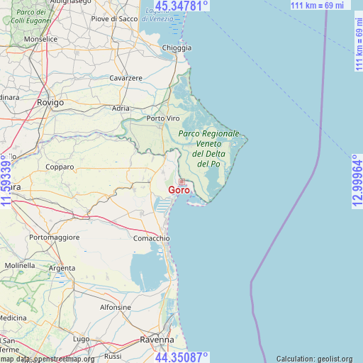
Goro GPS coordinates[2]
44° 51' 5.4" North, 12° 17' 47.436" East
| Map corner | latitude | longitude |
|---|---|---|
| Upper-left | 45.34781°, | 11.59339° |
| Center: | 44.8515°, | 12.29651° |
| Lower-right: | 44.35087°, | 12.99964° |
| Map W x H: | 110.8×110.8 km | = 68.8×68.8mi |
| max Lat: | 47.04031° ⇑42.9% North |
| Goro: | 44.8515° |
| min Lat: | ⇓57.1% South 35.50142° |
| min Long | Goro | max Long |
| 6.69888° | 12.29651° | 18.48682° |
| W 59.8%⇐ | ⇒40.2% E |
Elevation
Elevation of Goro is -2 m = -7 ft, and this is 308.7 m = 1013 ft below average elevation for this country.
| Max E: |
2085 m = 6841 ft | 100% |
| Avg. | 306.7 m = 1006 ft | |
| Goro | -2 m = -7 ft | |
Min E: |
-4 m = -13 ft | 0% |
See also: Italy elevation on elevation.city.
Geographical zone
Goro is located in North temperate zone (between Tropic of Cancer and the Arctic Circle). Distance of this Northern Tropic circle is 2381.1 km =1479.5 mi to South.| Distance of | km | miles | from Goro |
|---|---|---|---|
| North Pole | 5020 | 3119.3 | to North |
| Arctic Circle | 2414.2 | 1500.1 | to North |
| Tropic Cancer | 2381.1 | 1479.5 | to South |
| Equator | 4987 | 3098.8 | to South |


Nearby cities:
15 places around Goro: (largest is in red/bold)
• Bosco Mesola
5.8 km =3.6 mi,  298°
298°
• Ca' Tiepolo
11.3 km =7 mi,  17°
17°
• Codigoro
14.8 km =9.2 mi,  261°
261°
• Donzella
9.2 km =5.7 mi, 17°
• Gorino
5.1 km =3.2 mi,  128°
128°
• Lagosanto
15.8 km =9.8 mi,  231°
231°
• Lido delle Nazioni
13.1 km =8.1 mi,  200°
200°
• Mesola
9 km =5.6 mi,  325°
325°
• Monticelli
11.2 km =7 mi,  308°
308°
• Pontelangorino
11.7 km =7.3 mi,  275°
275°
• Pontemaodino
11.7 km =7.3 mi, 260°
• Porto Tolle
11.1 km =6.9 mi,  11°
11°
• Rivà
10.3 km =6.4 mi, 328°
• San Giuseppe
15.7 km =9.8 mi, 203°
• Scardovari
13.5 km =8.4 mi,  67°
67°
Sources, notices
• [Note1] Compared only with cities in Italy existing in our database
• [Src1] Map data: © OpenStreetMap contributors (CC-BY-SA)
• [Src2] Other city data from geonames.org with taken over terms of usage.
• [Src3] Geographical zone / Annual Mean Temperature by Robert A. Rohde @ Wikipedia
