Visco geodata
Visco (Friuli Venezia Giulia) is a seat of a third-order administrative division; located in Italy in Europe/Rome (GMT+2) time zone. With population of 767 people, there are 7836 cities with bigger population in this country. Compared to other cities in Italy, 89% of cities are located further ↓South; 72% of cities are located further ←West and 88.3% of cities have higher elevation than Visco. Note1
Administrative division(s):
- Level 1: Friuli Venezia Giulia
- Level 2: Provincia di Udine
- Level 3: Visco


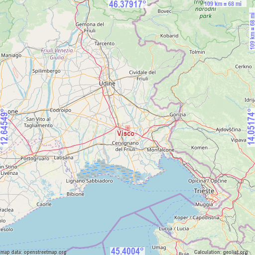
Visco GPS coordinates[2]
45° 53' 30.984" North, 13° 20' 54.996" East
| Map corner | latitude | longitude |
|---|---|---|
| Upper-left | 46.37917°, | 12.64549° |
| Center: | 45.89194°, | 13.34861° |
| Lower-right: | 45.4004°, | 14.05174° |
| Map W x H: | 108.8×108.8 km | = 67.6×67.6mi |
| max Lat: | 47.04031° ⇑11% North |
| Visco: | 45.89194° |
| min Lat: | ⇓89% South 35.50142° |
| min Long | Visco | max Long |
| 6.69888° | 13.34861° | 18.48682° |
| W 72%⇐ | ⇒28% E |
Elevation
Elevation of Visco is 22 m = 72 ft, and this is 284.7 m = 934 ft below average elevation for this country.
| Max E: |
2085 m = 6841 ft | 88.3% |
| Avg. | 306.7 m = 1006 ft | |
| Visco | 22 m = 72 ft | |
Min E: |
-4 m = -13 ft | 11.7% |
See also: Italy elevation on elevation.city.
Geographical zone
Visco is located in North temperate zone (between Tropic of Cancer and the Arctic Circle). Distance of this North polar circle is 2298.5 km =1428.2 mi to North.| Distance of | km | miles | from Visco |
|---|---|---|---|
| North Pole | 4904.4 | 3047.5 | to North |
| Arctic Circle | 2298.5 | 1428.2 | to North |
| Tropic Cancer | 2496.8 | 1551.4 | to South |
| Equator | 5102.7 | 3170.7 | to South |


Nearby cities:
15 places around Visco: (largest is in red/bold)
• Aiello del Friuli
2.3 km =1.4 mi,  156°
156°
• Bagnaria Arsa
5 km =3.1 mi,  259°
259°
• Campolongo al Torre
4.9 km =3 mi,  129°
129°
• Campolongo al Torre-Cavenzano
4.5 km =2.8 mi,  135°
135°
• Castions delle Mura
6.3 km =3.9 mi,  216°
216°
• Chiopris
5.8 km =3.6 mi,  48°
48°
• Ialmicco
2.4 km =1.5 mi,  355°
355°
• Medea
6.5 km =4 mi,  64°
64°
• Palmanova
3.3 km =2.1 mi,  296°
296°
• Perteole
5.2 km =3.2 mi,  148°
148°
• San Vito al Torre
2.2 km =1.4 mi,  78°
78°
• Sevegliano
3.4 km =2.1 mi, 261°
• Sottoselva
2.9 km =1.8 mi,  318°
318°
• Strassoldo
4.4 km =2.7 mi,  207°
207°
• Trivignano Udinese
6 km =3.7 mi,  353°
353°
Sources, notices
• [Note1] Compared only with cities in Italy existing in our database
• [Src1] Map data: © OpenStreetMap contributors (CC-BY-SA)
• [Src2] Other city data from geonames.org with taken over terms of usage.
• [Src3] Geographical zone / Annual Mean Temperature by Robert A. Rohde @ Wikipedia
