Palmanova geodata
Palmanova (Friuli Venezia Giulia) is a seat of a third-order administrative division; located in Italy in Europe/Rome (GMT+2) time zone. With population of 2,515 people, there are 3505 cities with bigger population in this country. Compared to other cities in Italy, 89.3% of cities are located further ↓South; 71.5% of cities are located further ←West and 86.4% of cities have higher elevation than Palmanova. Note1
Administrative division(s):
- Level 1: Friuli Venezia Giulia
- Level 2: Provincia di Udine
- Level 3: Palmanova


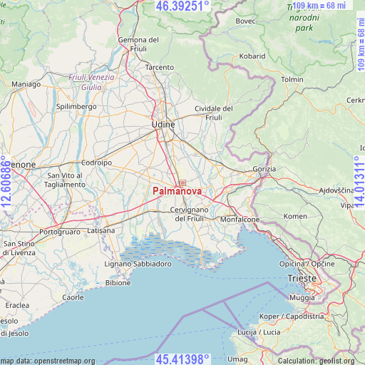
Palmanova GPS coordinates[2]
45° 54' 19.44" North, 13° 18' 35.928" East
| Map corner | latitude | longitude |
|---|---|---|
| Upper-left | 46.39251°, | 12.60686° |
| Center: | 45.9054°, | 13.30998° |
| Lower-right: | 45.41398°, | 14.01311° |
| Map W x H: | 108.8×108.8 km | = 67.6×67.6mi |
| max Lat: | 47.04031° ⇑10.7% North |
| Palmanova: | 45.9054° |
| min Lat: | ⇓89.3% South 35.50142° |
| min Long | Palmanova | max Long |
| 6.69888° | 13.30998° | 18.48682° |
| W 71.5%⇐ | ⇒28.5% E |
Elevation
Elevation of Palmanova is 27 m = 89 ft, and this is 279.7 m = 918 ft below average elevation for this country.
| Max E: |
2085 m = 6841 ft | 86.4% |
| Avg. | 306.7 m = 1006 ft | |
| Palmanova | 27 m = 89 ft | |
Min E: |
-4 m = -13 ft | 13.6% |
See also: Italy elevation on elevation.city.
Geographical zone
Palmanova is located in North temperate zone (between Tropic of Cancer and the Arctic Circle). Distance of this North polar circle is 2297 km =1427.3 mi to North.| Distance of | km | miles | from Palmanova |
|---|---|---|---|
| North Pole | 4902.9 | 3046.5 | to North |
| Arctic Circle | 2297 | 1427.3 | to North |
| Tropic Cancer | 2498.3 | 1552.4 | to South |
| Equator | 5104.2 | 3171.6 | to South |


Nearby cities:
15 places around Palmanova: (largest is in red/bold)
• Aiello del Friuli
5.3 km =3.3 mi,  132°
132°
• Bagnaria Arsa
3.1 km =1.9 mi,  218°
218°
• Bicinicco
5.3 km =3.3 mi,  303°
303°
• Castions delle Mura
6.6 km =4.1 mi,  186°
186°
• Chiopris
7.7 km =4.8 mi,  72°
72°
• Felettis
4 km =2.5 mi,  287°
287°
• Gonars
5.2 km =3.2 mi,  260°
260°
• Ialmicco
2.9 km =1.8 mi, 72°
• San Vito al Torre
5.2 km =3.2 mi,  101°
101°
• Santa Maria la Longa
3.6 km =2.2 mi,  333°
333°
• Sevegliano
2 km =1.2 mi, 190°
• Sottoselva
1.3 km =0.8 mi,  58°
58°
• Strassoldo
5.5 km =3.4 mi,  170°
170°
• Trivignano Udinese
5.1 km =3.2 mi,  27°
27°
• Visco
3.3 km =2.1 mi,  116°
116°
Sources, notices
• [Note1] Compared only with cities in Italy existing in our database
• [Src1] Map data: © OpenStreetMap contributors (CC-BY-SA)
• [Src2] Other city data from geonames.org with taken over terms of usage.
• [Src3] Geographical zone / Annual Mean Temperature by Robert A. Rohde @ Wikipedia
